Geometric pattern of the mountains
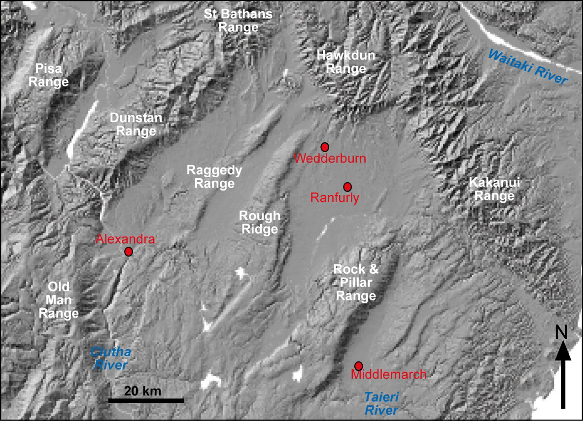 Topographic image of central Otago. The northeast margin of the schist belt is a set of faulted northwest trending greywacke and semischist ranges (Kakanui and Hawkdun Ranges). Central Otago is dominated by northeast trending ranges (Pisa, Dunstan, Raggedy, Rough Ridge, and Rock & Pillar Ranges) made up of folded schist. A structurally complex zone occurs where these different structures intersect.
The most prominent mountain uplift has occurred along the northwest trending zone between Otago and Canterbury. This uplift has been facilitated by reactivation of the major fault zones, the Waihemo, Hawkdun, and Blue Lake Fault Zones, especially the former two. This has given rise to the prominent northwest trending barrier between Otago and Canterbury: the Kakanui, Hawkdun and St Bathans Ranges. These ranges have been rising for the past 5 million years or more, and are still active. Central Otago is dominated by northeast trending ranges and intervening basins that have been formed by folding of the schist into a series of antiformal ridges and synformal basins. The synformal basins contain remnants of folded sediments resting on the schist basement. These folds began to rise about 1 million years ago and are still active. There are fault zones beneath the folds, and these faults have branches that reach the surface on the southeast side of the ranges. Consequently, the ranges have an asymmetrical shape, with steep southeastern sides. Likewise, the basins are asymmetrical, with steep margins on the northwestern sides. The boundary between the schist and the Miocene sediments is commonly steeply dipping or even vertical on this margin. Historic gold miners has to deal with these steeply dipping zones as they followed the gold-rich zone at the base of the Miocene sediments, and eventually had to give up as it became too deep to work.
Topography and tectonics
![Oblique digital terrain model (compiled by [www.geographx.co.nz]) of the structurally complex intersection zone of northeast and northwest ranges on the northeast margin of the Otago Schist belt. Naseby alluvial gold mining area (green forest) is at centre right, Wedderburn is close to the left of this forest, Oturehua is at centre, and St Bathans is at upper left. Smooth-topped schist fold ranges have steep southeastern slopes above active faults. Eroded fault scarps of the greywacke ranges face into central Otago, with flat tops and gentle slopes of the preserved Waipounamu Erosion Surface on the Canterbury side.](https://www.otago.ac.nz/__data/assets/image/0017/224018/otago070963.jpg) Oblique digital terrain model (compiled by [www.geographx.co.nz]) of the structurally complex intersection zone of northeast and northwest ranges on the northeast margin of the Otago Schist belt. Naseby alluvial gold mining area (green forest) is at centre right, Wedderburn is close to the left of this forest, Oturehua is at centre, and St Bathans is at upper left. Smooth-topped schist fold ranges have steep southeastern slopes above active faults. Eroded fault scarps of the greywacke ranges face into central Otago, with flat tops and gentle slopes of the preserved Waipounamu Erosion Surface on the Canterbury side.
Oblique digital terrain model (compiled by [www.geographx.co.nz]) of the structurally complex intersection zone of northeast and northwest ranges on the northeast margin of the Otago Schist belt. Naseby alluvial gold mining area (green forest) is at centre right, Wedderburn is close to the left of this forest, Oturehua is at centre, and St Bathans is at upper left. Smooth-topped schist fold ranges have steep southeastern slopes above active faults. Eroded fault scarps of the greywacke ranges face into central Otago, with flat tops and gentle slopes of the preserved Waipounamu Erosion Surface on the Canterbury side.
The dry climate of Central Otago means that there is only minor erosion of the topography as the faulted or folded mountain rise. Hence, the topography visible at the surface gives a good view of the active tectonic processes that are occurring now and have occurred over the past few million years. Almost all topographic features reflect active tectonics, although there has always been some erosional modification. The flat tops and smooth slopes of the northeast trending ranges are remnants of the little-modified Waipounamu Erosion Surface beneath the Miocene sediments. This surface and overlying Miocene quartz gravels is commonly gold-bearing and has been mined historically in many places, especially along the margins of the uplifting ranges. The broad basins of central Otago are not erosional valleys; they reflect structural down-warping of the schist between the upfolded ranges. Minor deposition of gravels in the basins has occurred as the ranges went up, but these gravels are thin. Some of these gravels contain alluvial gold recycled from the Miocene sediments that were uplift and eroded from rising ranges. The northwest ranges are asymmetrical in shape because their southwestern sides are controlled by faults, whereas their northeastern sides still retain large flat areas that are remnants of the depositional surface below the overlying sediments. The faulted southwestern slopes of the greywacke ranges have been modified by short steep erosional gulleys.
The northeast trending schist ranges are evolving progressively northeast as well as getting higher and wider. Hence, they now impinge on the northwest trending faulted greywacke ranges. This forms a structurally complex zone in which both northeast and northwest structures are currently active. These different structures locally interfere with each other, giving some small-scale complicated geometry of the resulting topography. These structural complications also affected the distribution and shape of remnants of the Miocene gold-bearing sediments.
River drainage redirection
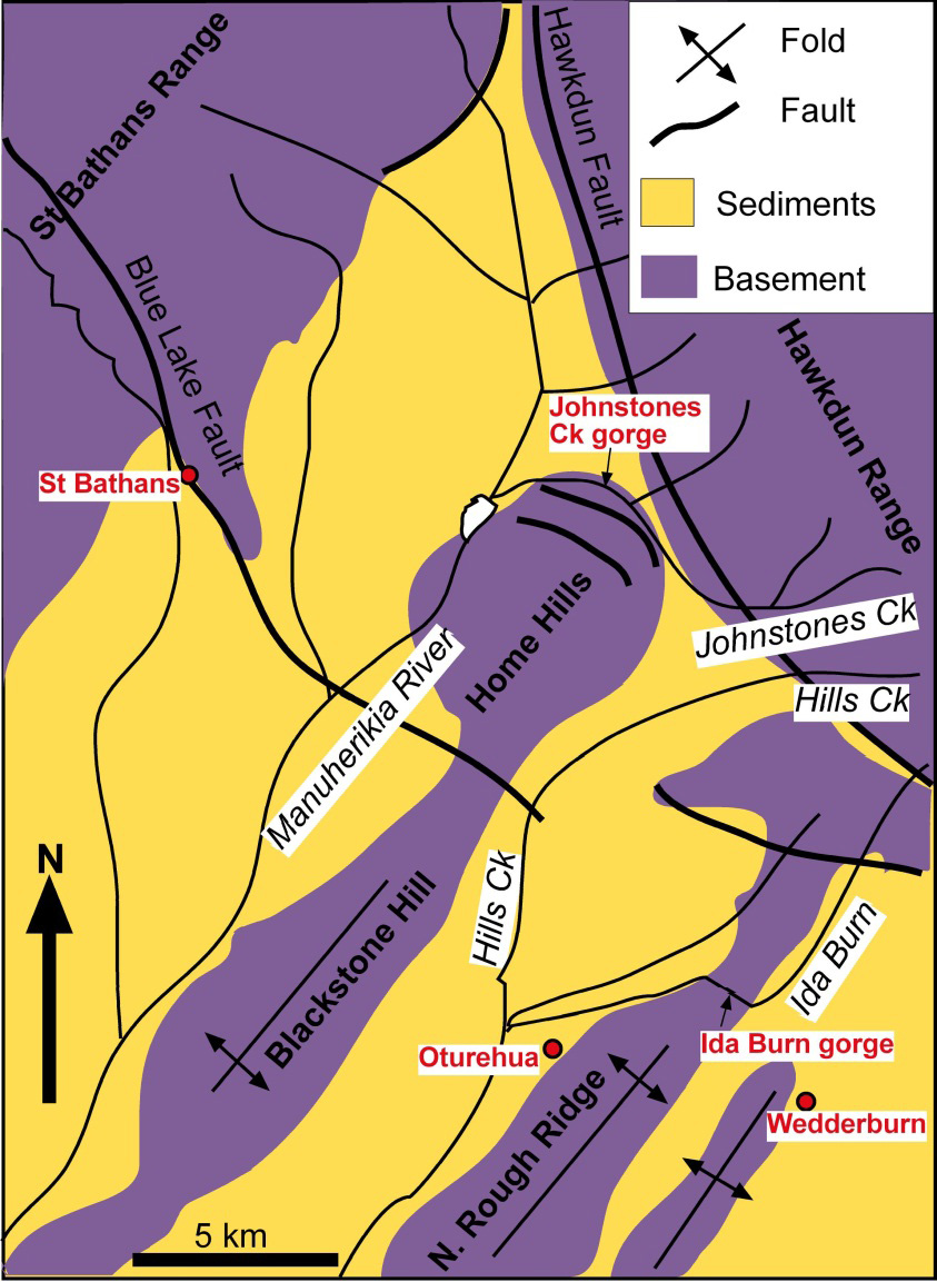 Summary geological map of the complex structural zone at the northeast margin of the Otago Schist belt, showing the rivers draining from the Hawkdun Range that have been affected by the rise of the northeast trending fold ranges (Blackstone Hill, Rough Ridge). River diversion caused by increasing deformation has resulted in the Johnstones Creek gorge cut around the end of the evolving Home Hills dome. The Ida Burn gorge cuts through North Rough Ridge between Wedderburn and Oturehua.
The intersection of NW- and NE-trending active structures along the Hawkdun Fault Zone in central Otago has resulted in uplift of the synformal (down-folded) basins in the complex structural zone. These basins are now the highest basins in central Otago, and continued compression along northeast and northwest structures is causing further uplift. This basin uplift has caused some streams to flow at low gradients down the rising basin surfaces. Stream diversion has occurred out of two basins into the adjacent basin where local base level is at lower altitude, thereby increasing the gradients of these streams. To reach the adjacent basin, each diverted stream had to cross what is now an antiformal (up-folded) ridge, and these streams have subsequently cut gorges to fresh basement through these rising ridges. The diversions of streams to lower altitude in adjacent basins can occur because of oblique intersection of the antiformal ridges with the Hawkdun Range. This ensures that the head of each basin to the southeast is higher than the floor of the adjacent basin to the northwest.
The intersection of NW- and NE-trending active structures along the Hawkdun Fault Zone in central Otago has resulted in uplift of the synformal (down-folded) basins in the complex structural zone. These basins are now the highest basins in central Otago, and continued compression along northeast and northwest structures is causing further uplift. This basin uplift has caused some streams to flow at low gradients down the rising basin surfaces. Stream diversion has occurred out of two basins into the adjacent basin where local base level is at lower altitude, thereby increasing the gradients of these streams. To reach the adjacent basin, each diverted stream had to cross what is now an antiformal (up-folded) ridge, and these streams have subsequently cut gorges to fresh basement through these rising ridges. The diversions of streams to lower altitude in adjacent basins can occur because of oblique intersection of the antiformal ridges with the Hawkdun Range. This ensures that the head of each basin to the southeast is higher than the floor of the adjacent basin to the northwest.
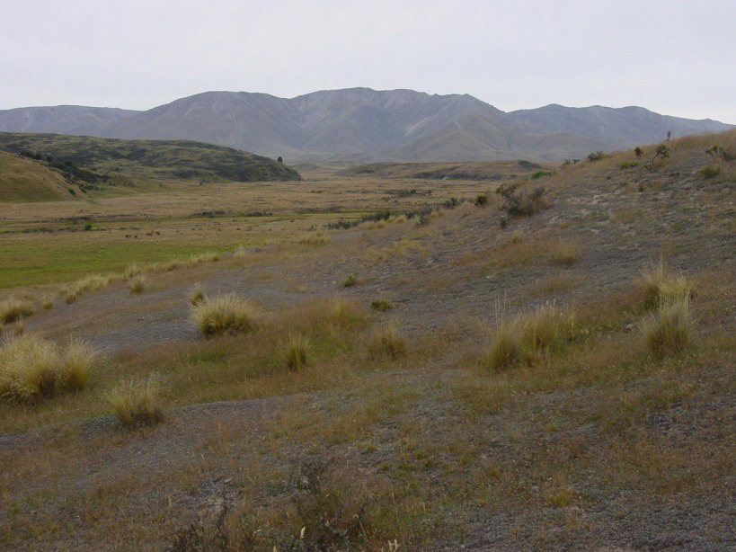 Ida Burn, near the town of Wedderburn, draining from Mt Ida on the Hawkdun Range. The river has been diverted to the left by uplift of the northern extension of Rough Ridge (right foreground).
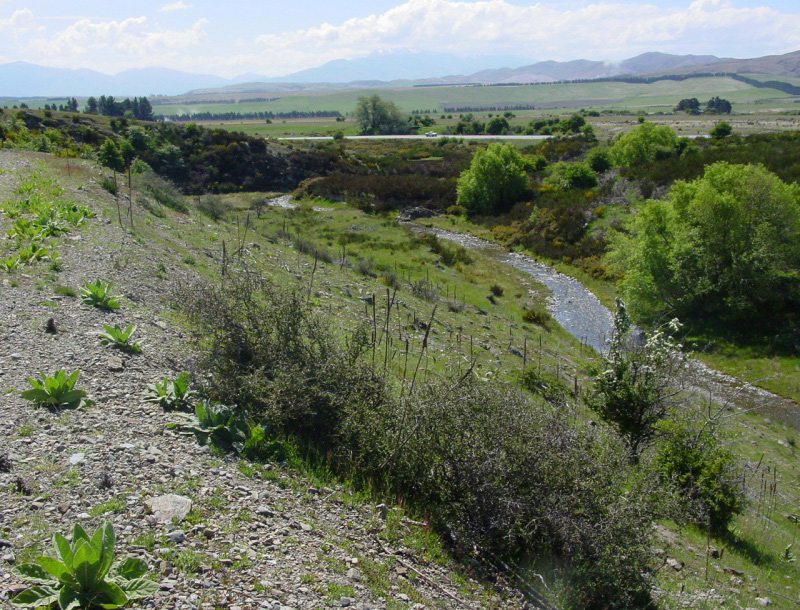 Ida Burn upstream of Oturehua is cutting through a schist gorge after being diverted 90° by tectonic uplift (as in photo above). Rail trail cutting is in left foreground.
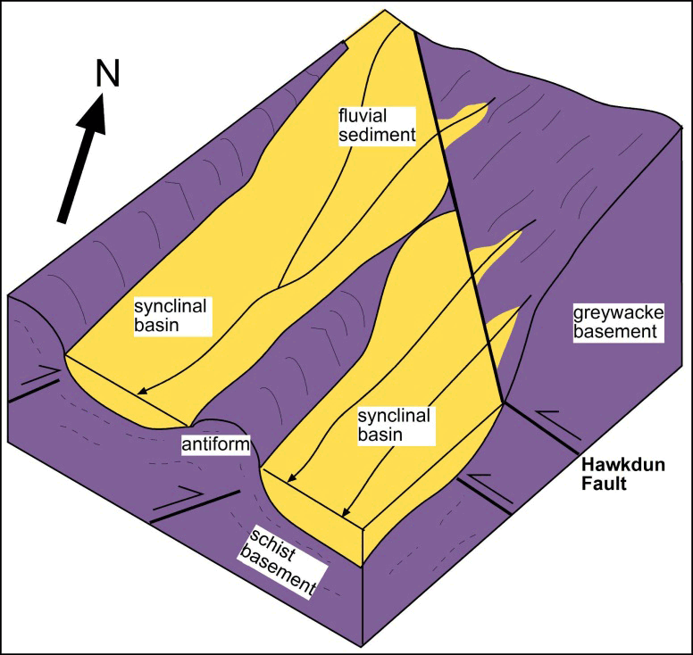 Sketch block diagram showing the geometry of the rivers before diversion as the mountains rise in the intersection zone between northeast and northwest trending ranges on the northeast margin of the Otago Schist belt.
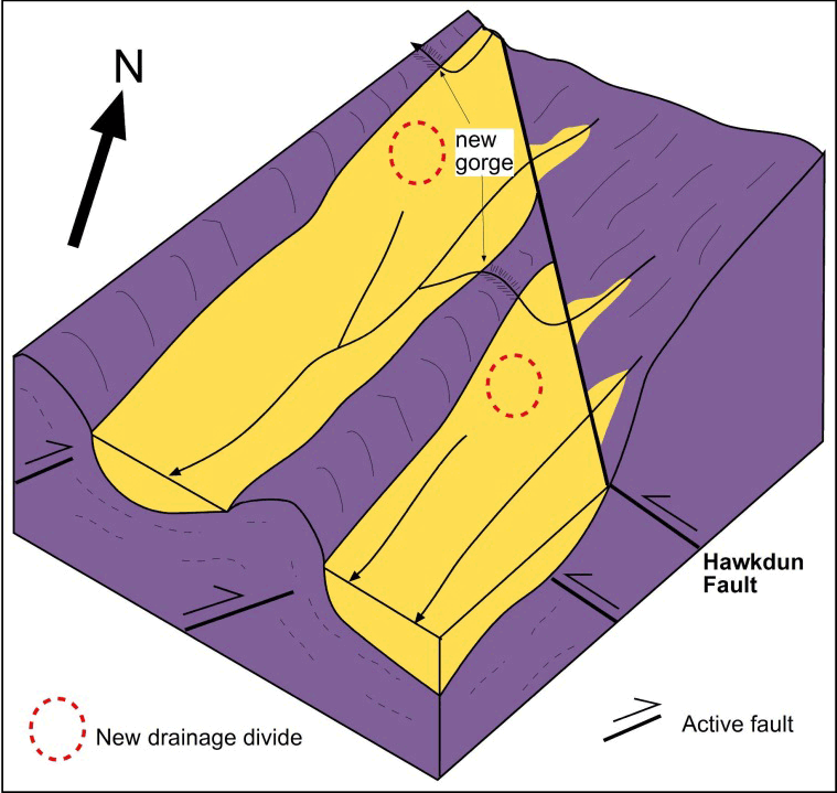 Sketch block diagram of the modified river drainage pattern after diversion of some of the rivers as the northeast trending folds become tighter and extended farther northeast. Uplift in the basins forces rivers to divert through gorges in adjacent basement ridges.
More information
- Youngson, J.H.; Craw, D.; Landis, C.A.; Schmitt, K.R. 1998 Redefinition and interpretation of late Miocene-Pleistocene terrestrial stratigraphy, Central Otago, New Zealand. New Zealand Journal of Geology and Geophysics 41: 51-68. doi:10.1080/00288306.1998.9514790
- Craw, D., Burridge, C., Waters, J. 2007. Geological and biological evidence for drainage reorientation during uplift of alluvial basins, central Otago, New Zealand. New Zealand Journal of Geology and Geophysics 50: 367-376. doi:10.1080/00288300709509844
Related
- Crustal structure and topography of the Otago northeast margin
- Initiation of the fault zones on the northeast Otago margin
- Faulting and erosion of the Macraes gold deposit
- Gold-bearing veins at Oturehua
- Blue Lake Fault Zone
- Graphite and gold on the northeast schist margin
- Gold and arsenic in pyrite
- Waipounamu Erosion Surface
- Alluvial gold along the northeast Otago margin
- Rise of modern mountains on Otago's northeast margin
- Patearoa gold: Alluvial concentrations in a dynamic environment