Back to the start | Next (Harold Creek)
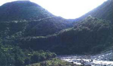 The photograph is looking south and shows high river terraces truncated by the Alpine Fault which runs down the gully on the right of the photo. The highest terrace is tentatively radiocarbon dated at 10,800 yr BP and is displaced vertically by 80 m, giving a dip-slip rate on the fault of c. 6.3 mm/yr.