Introduction
Otago is famous for its gold deposits, and the European history of Otago has been closely associated with mining of that gold. The accumulation of gold in Otago involved a wide range of geological processes that initially occurred deep in the Earth's crust in the earliest stages of formation of what we now call the Otago Schist basement. The early gold accumulations were then progressively uplifted and eroded to release gold into the sedimentary environment. Continued uplift and erosion caused that gold to be recycled into progressively younger sediments, and at the same time chemical processes acted on the gold to change the size and shape of gold particles. Some of this relatively young activity led to formation of gold nuggets, but most Otago gold is fine grained. All these processes are continuing to occur today, although the amounts of gold moving around in the environment are small in relation to human interests. The following brief account is intended to provide an introduction to Otago and its gold, and this account contains links to other pages that present some more details of particular aspects.
Plate tectonic origins
The Otago Schist formed from a thick pile of sedimentary rocks that were deposited off the coast of the supercontinent, Gondwana, which included Australia and Antarctica. The Australian component of Gondwana was the nearest neighbour, and eastern Australia is made up of belts of rock that are very similar to the Otago Schist, but were bulldozed against the Gondwana landmass at earlier times. Each stage of accretion of sedimentary piles was accompanied by faulted stacking of piles of sediment into thick complexes called accretionary complexes. This stacking was accompanied by heating of the sediments, which released water and metals (especially gold, tungsten, arsenic, and antimony). The hot water concentrated metals from large volumes of sediments into narrow fault structures, and these became the gold deposits that we see in the basement rocks today. The gold deposits of Victoria, in southeast Australia, were formed nearly 400 million years ago, and a small fragment of the Victorian basement (Lachlan belt), with gold deposits, is found on the west coast of the South Island of New Zealand. The most important of these deposits occur in the Reefton goldfield.
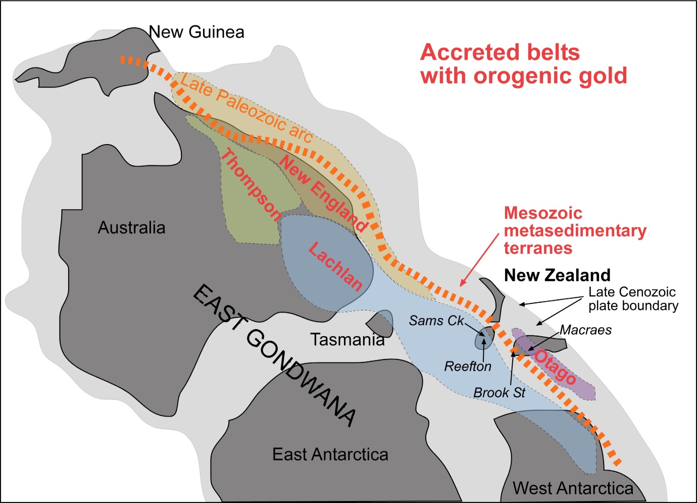
Sketch map (modified from N Mortimer, GNS Science) of reconstructed portions of the Gondwana supercontinent (dark grey), with belts of accreted sediments on the eastern side. The Otago Schist formed as part of the outermost of these accretionary belts, about 200 million years ago.
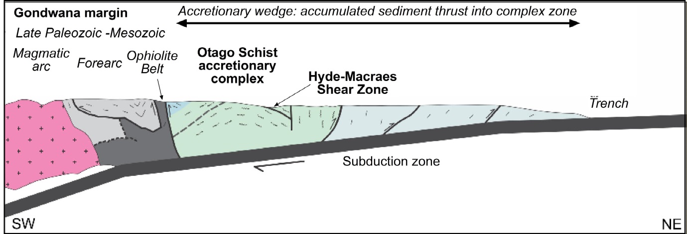
Sketch cross section through the 200 million year old accretionary complex that became the Otago Schist (centre, green) and Canterbury greywacke (right, blue). The largest gold deposit in Otago, at Macraes, formed in a large regional scale structure, the Hyde-Macraes Shear Zone.
Schist was formed about 200 million years ago when an especially thick pile of sediment was thrust into a pile and heated up to cause the formation of the schist basement that we see today. Metal mobility and emplacement probably began about 200 million years ago as well, but the oldest gold deposits we know about are about 140 million years old. That includes the largest deposit, at Macraes, which has at least 10 million ounces of gold in a single large structure, the Hyde-Macraes Shear Zone. This gold is also accompanied by abundant tungsten, in the mineral scheelite (CaWO4) and arsenic in the mineral arsenopyrite (FeAsS). At about the same time as the Macraes deposit was forming, a set of faults on the far side of the schist belt became mineralised with the same minerals as at Macraes, but in that area (Glenorchy), the scheelite dominates over gold in most of these structures.
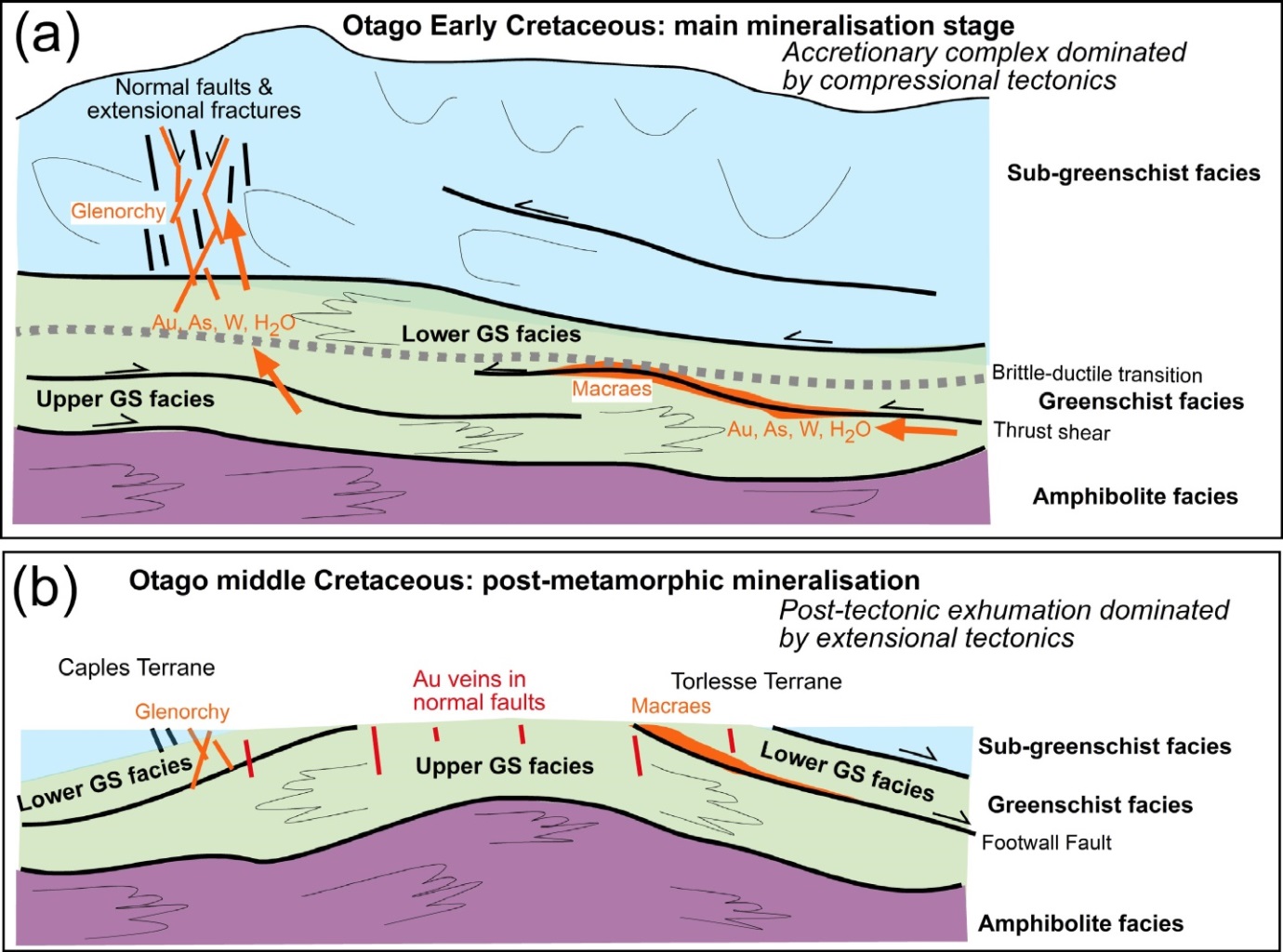
Sketch cartoons of formation of gold and tungsten deposits in structures in the Otago Schist basement. (a) Formation of Macraes and Glenorchy deposits (orange) about 140 million years ago while the accretionary complex was still being formed by compressional deformation at the Gondwana margin. (b) Formation of gold-bearing quartz veins about 110 million years ago when Gondwana was breaking up and New Zealand was about to separate from Australia. These latter veins formed while the Otago Schist was being extended tectonically during Gondwana breakup.
By about 110 million years ago, Gondwana was starting to break up into the continents that we know today. As a result, the continental rocks were stretched, opening up numerous extensional (= normal) faults. The Otago Schist became extended at that time, and numerous normal faults cut across the landscape. Some of these faults occurred at a low angle, and large slices of rock slid off the top of the schist belt. One of the most prominent of these is called the Footwall Fault as it developed at what is now the base of the Hyde-Macraes Shear Zone, and cut off the Macraes gold deposit. At about the same time, numerous steeply dipping normal faults opened up fractures that allowed hot water to transport gold and quartz to shallow levels in the schist belt. The resultant gold-bearing quartz veins are a common feature of the Otago landscape, such as at Barewood, Nenthorn and Oturehua.
Earliest river sediments
The long history of accretion and uplift of the Otago Schist undoubtedly involved numerous rivers and associated river sediments. However, the oldest preserved river sediments are about 110 million years old, and these accumulated in river valleys that were controlled by extensional structures cutting the basement schist. The most prominent of these rivers developed on the northeastern and southwestern edges of the schist belt, near to modern-day Palmerston (Waihemo) and Kaitangata respectively. The drainage patterns of these rivers are poorly known because of subsequent uplift and erosion. However, the fault structures and the valleys they controlled had, and still have, a northwest orientation. The sediments that were deposited on the northeastern side of the schist belt are now called the Horse Range Formation, and are best exposed at Trotters Gorge (see initiation of the fault zones for more info on Horse Range Formation). On the southwestern side of the schist belt, the oldest sediments are called the Henley Breccia. It is notable that both the Henley Breccia and the Horse Range Formation contain schist debris eroded from nearby basement, but neither of these formations contains significant gold eroded from the basement deposits.
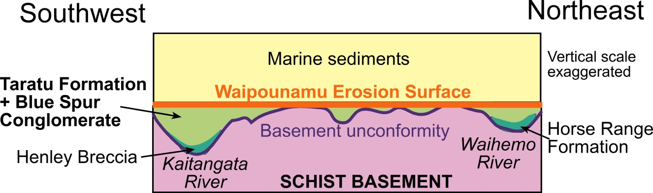
Sketch cross section along the east coast of Otago, showing the topography of major valleys that were controlled by normal faults on the margins of the schist belt between 110 and about 70 million years ago. These valleys hosted major rivers that drained the schist belt and adjacent rocks. The oldest sediments (dark green) do not contain significant alluvial gold, but some parts of the younger Taratu Formation do contain alluvial gold, including the famous Blue Spur deposits at Gabriels Gully.
The extensional faults that controlled the topography of early Otago continued to move, with uplift of ridges and down-dropping of valleys, through to at least 70 million years ago. Erosion of schist basement debris into the valleys was followed by uplift of those sediments and recycling of them again into the valleys. the end result of several cycles of this activity was debris that was dominated by resistant quartz pebbles, while the softer micas in the schist were washed to the sea. The quartz pebbles and associated sediments form a set of deposits called the Taratu Formation, which is found all along the east coast of Otago. The Taratu Formation does contain gold eroded from the deposits in the schist basement, although this gold is typically widely dispersed through the sediments. However, a set of coarse gravels made up of debris eroded from the adjacent basement fault scarp, with only minor quartz pebbles, occurs as part of the Taratu Formation between Waitahuna and Lawrence on the southwest side of the schist belt. This Blue Spur Conglomerate contains eroded gold that has been concentrated into some layers (see Gold at Gabriels Gully for more info on the Blue Spur Conglomerate). These alluvial gold deposits, or placers, were the sources for a lot of gold that was mined in the early stages of the Otago gold rush in the 1860s.
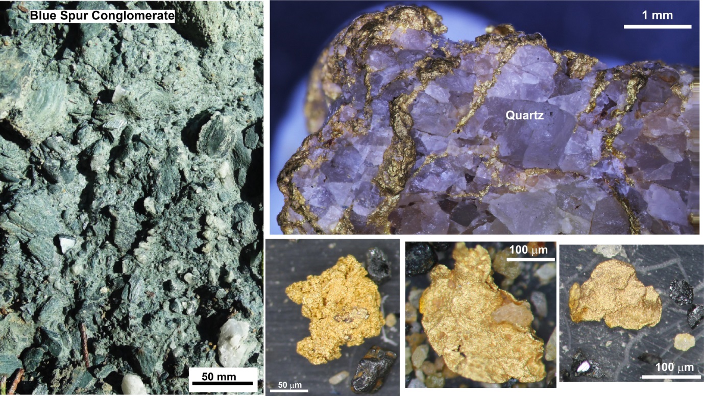
Blue Spur Conglomerate and some examples of alluvial gold from the conglomerate.
Marine incursion
New Zealand became fully separated from Australia between 80 and 60 million years ago, as part of the on-going breakup of Gondwana. The Otago landscape began to submerge beneath the sea about 60 million years ago as extension and thinning of the underlying crust continued to occur. Some erosion and recycling of quartz pebble sediments continued in inland areas, and remnants of gold-bearing quartz pebble conglomerates are common in the Macraes, Hyde and Patearoa areas. However, inundation by the sea, with deposition of marine sediments, occurred progressively farther inland across the schist basement, with formation of a widespread flat surface, the Waipounamu Erosion Surface.
New plate boundary
A new tectonic plate boundary formed across the South Island, with the inception of the Alpine Fault about 25 million years ago. This brought the extensional stretching of the Otago Schist crust to a halt. The crust began to thicken again under growing mountains in northwest Otago (Mt Aspiring area), with only minor uplift farther to the east. The mountains grew progressively to the northeast to become the main Southern Alps mountain chain. A new generation of gold-bearing quartz veins formed in extensional fractures and faults in the Otago mountains soon after the land rose from beneath the sea. Similar gold-bearing veins have continued forming throughout the Southern Alps as they grew progressively along the Alpine Fault, and these processes are still continuing today beneath the mountains.
See also:
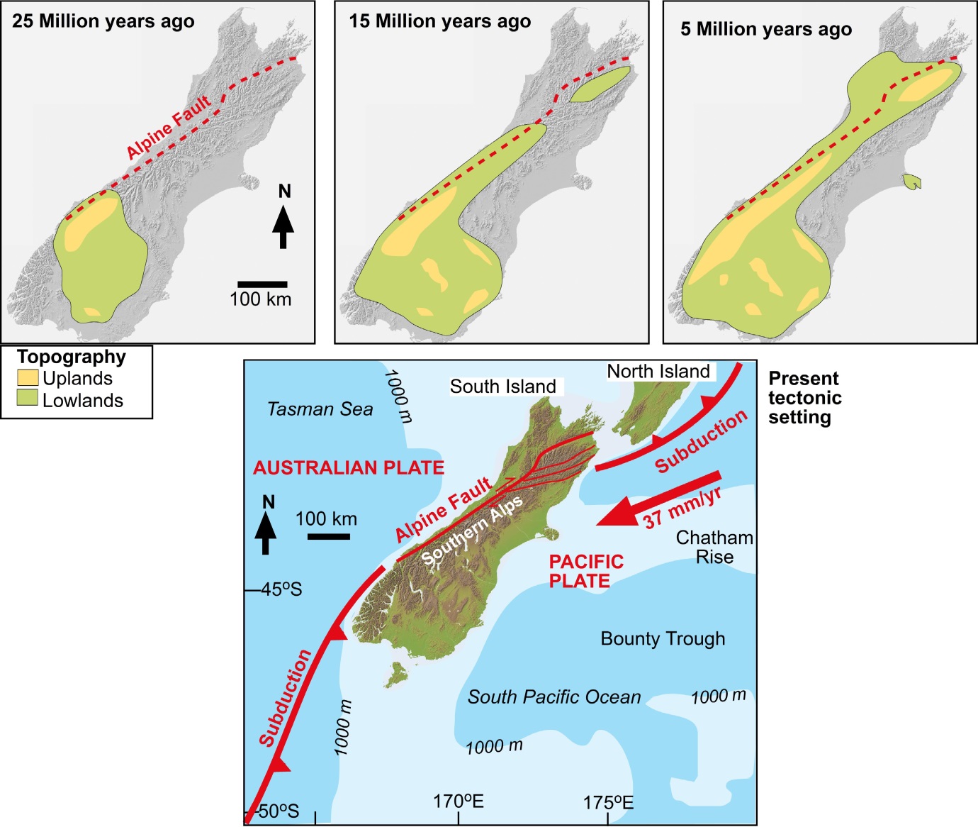
Evolution of the Otago landscape in the South Island as a result of the development of the new Alpine Fault tectonic plate boundary 25 million years ago. Initially, Otago was the only part of the South Island that emerged from beneath the sea, with development of mountains in NW Otago and lowlands farther east and extending to Southland. By 15 million years ago, the mountains had extended farther to the northeast, and the Southern Alps had largely formed as a continuous chain by 5 million years ago. The present plate tectonic geometry emphasises that the Alpine Fault plate boundary is the main reason New Zealand is emergent land in the Pacific Ocean, and most of the continental crust of the region remains below sea level.
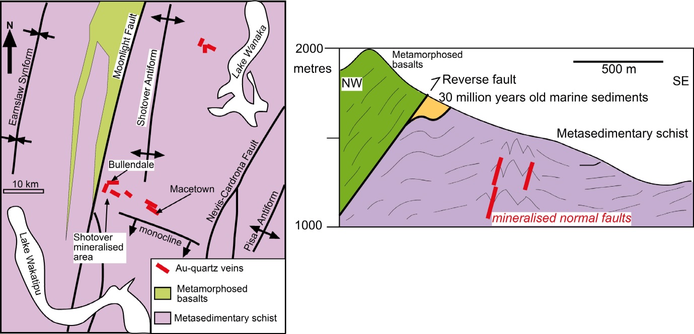
Map and cross section of gold-bearing quartz veins formed in the Otago mountains soon after emergence from beneath the sea about 25 million years ago. Erosion of gold from these veins contributed to the rich alluvial gold deposits of the Shotover and Arrow Rivers.
Evolution of present Otago landscape
The present Otago landscape is very young, and still tectonically active. When Otago emerged from beneath the sea, most rivers drained southwards, and carried alluvial gold from Central Otago into Southland. That alluvial gold was partly derived from erosion of the new gold deposits forming in the mountains to the west. However, much of the alluvial gold in Central Otago and Southland was derived from erosion of the quartz pebble deposits that formed over Otago before the inundation by the sea, and these deposits were recycled to form new quartz pebble conglomerates about 20 million years ago.
See also:
The widespread gold-bearing quartz pebble deposits in Southland are largely recycled material from Otago. This southward transfer of alluvial gold and quartz debris from Otago ceased when the Old Man Range and associated ranges grew up between Otago and Southland, and most alluvial gold recycling was then only local, adjacent to growing ranges. At the same time a large lake, Lake Manuherikia developed over much of Central Otago, and dominated the landscape until about 5 million years ago.
Lake Manuherikia became filled with erosional debris(see Taieri River path) , and most of Central Otago became a large alluvial plain, similar to the modern Canterbury Plains, after about 5 million years ago. Some alluvial gold recycling and concentration occurred during these processes, but most gold became diluted by large volumes of gravel. Uplift of the northeast trending ranges that dominate the Central Otago landscape today only started about 1 million years ago, and this uplift has led to abundant erosion and recycling of alluvial gold into the modern rivers and associated older terraces.
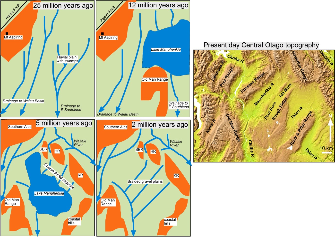
Sketch maps showing the evolution of Otago topography since the development of the Alpine Fault plate boundary25 million years ago. Initially, most major rivers drained to Southland, and this southward drainage continued in the mountains until about 1 million years ago. In contrast, Central Otago became covered in a large lake that was partly dammed by rise of the Old man Range between Otago and Southland about 12 million years ago. The lake persisted until about 5 million years ago, when it was filled with debris eroded from rising ranges on the margins of Central Otago. The northeast trending ranges that characterise Central Otago today have been forming only for the past 1 million years.
Chemical changes in gold during tectonic uplift
There are strong contrasts in sizes and shapes between much of the original gold formed deep in the Earth's crust, and the gold that occurs in the various alluvial deposits formed over the past 110 million years. These contrasts result from chemical processes that cause some gold to dissolve in surface and groundwaters, and then chemically redeposit on other gold particles, to increase the size of gold particles. Since most of the gold in the original deep-formed deposits is very fine grained (typically 0.01 millimetres), if these chemical processes had not occurred throughout the long tectonic history, there would be little or no alluvial gold found in Otago. Instead, that original fine grained gold would have all been washed to the sea.
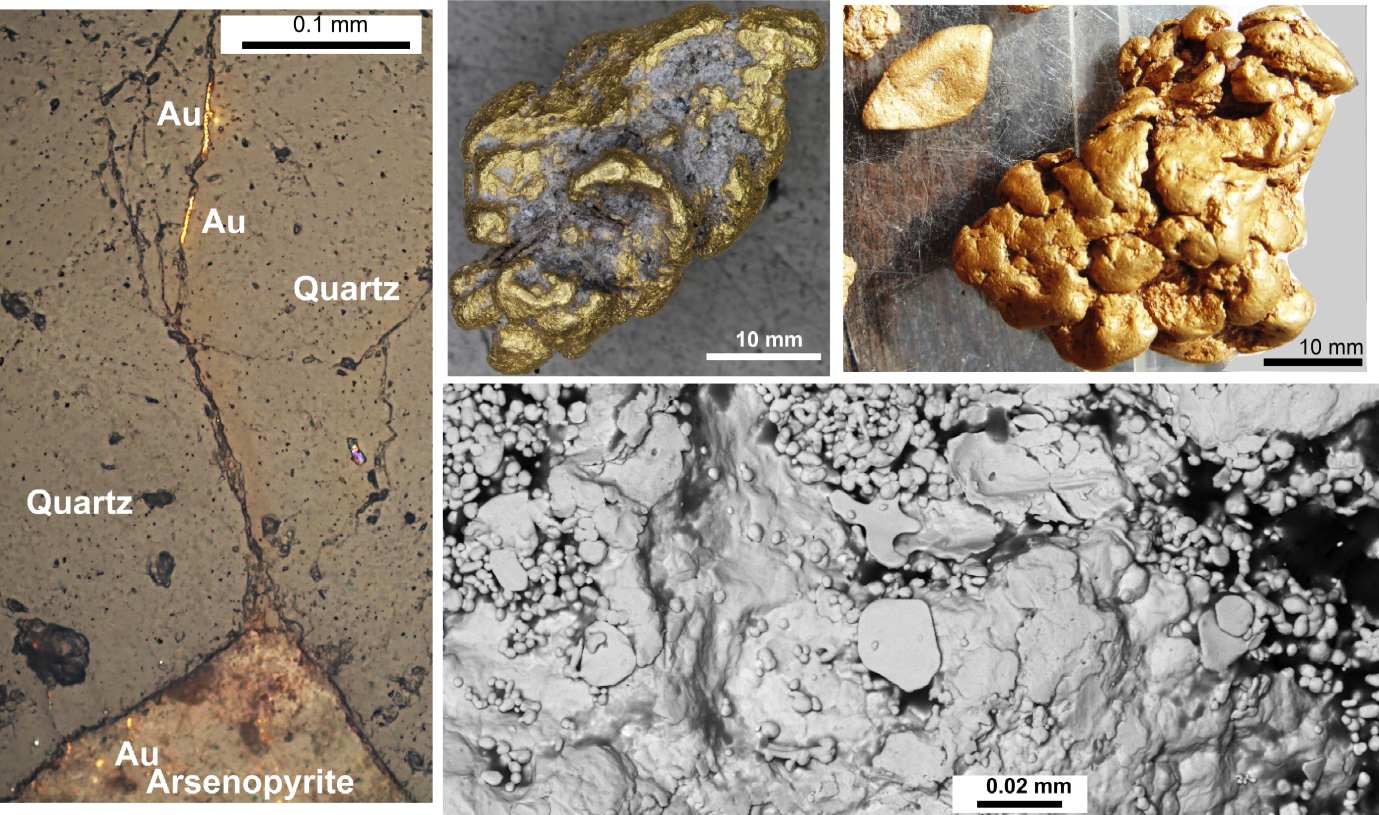
Images of gold from the lower slopes of Old Man Range, central Otago. On left, some small seams of gold have migrated up a crack in a quartz vein from an oxidised arsenopyrite grain at bottom (from Sam Stephens). At top are nuggets (from Mark Hesson) formed from chemical accumulation of gold during long-term oxidation of the schist basement and associated quartz pebble deposits. Rounding of the nuggets has been caused by local recycling during tectonic uplift. Bottom right is a scanning electron microscope image (from Gemma Kerr) of the surface of a gold nugget, showing additions of gold plates and irregular forms that may have been deposited by bacterial action.
Additional information
- Craw D 2013. River drainage reorientation during placer gold accumulation, southern New Zealand. Mineralium Deposita 48: 841–860.
- Craw D 2017. Placer gold and associated supergene mineralogy at Macraes Flat, East Otago, New Zealand. New Zealand Journal of Geology and Geophysics 60: 353-367.
- Craw D, Lilly K 2016 Gold nugget morphology and geochemical environments of nugget formation, southern New Zealand. Ore Geology Reviews 79: 301-315.
- Craw D, MacKenzie D 2016. Macraes gold deposit, New Zealand. SpringerBriefs in World Mineral Deposits. (Ed: Camprubi A, Gonzalez Jimenez A, Gonzalez F, Slack F), ISBN 978-3-319-35158-2, 130 pp.
- Craw D, Upton P, Walcott R, Burridge C, Waters J 2012. Tectonic controls on the evolution of the Clutha River catchment, New Zealand. New Zealand Journal of Geology and Geophysics 55, 345-359.
- Craw D, MacKenzie DJ, Grieve P 2015. Supergene gold mobility in orogenic gold deposits, Otago Schist, New Zealand. New Zealand Journal of Geology and Geophysics 58: 123-136.
- Craw D, Kerr G, Falconer D 2015. Mineralogy and provenance of auriferous Waimumu Quartz Gravels, Southland, New Zealand. New Zealand Journal of Geology and Geophysics 58: 281-295.
- Craw, D, Craw L, Burridge C, Wallis G, Waters J 2016. Evolution of the Taieri River catchment, East Otago, New Zealand. New Zealand Journal of Geology and Geophysics vol 59: 257-273.
- Craw D, Hesson M, Kerr G 2016. Morphological evolution of gold nuggets in proximal sedimentary environments, southern New Zealand. Ore Geology Reviews 80: 784-799.
- Craw, D., Upton P, Burridge C, Wallis G, Waters J 2016. Rapid biological speciation driven by tectonic evolution in New Zealand. Nature Geoscience 9: 140-144.
- Kerr G, Craw D 2017. Mineralogy and geochemistry of biologically-mediated gold mobilisation and redeposition in a semiarid climate, southern New Zealand. in: Reith F; Shuster J (eds), Special Issue "Geomicrobiology and biogeochemistry of precious metals”, Minerals 7, 147, doi:10.3390/min7080147
- MacKenzie D, Farmer L, Moore J, Craw D. 2016. Contrasting coeval paragenesis of gold and scheelite in an orogenic hydrothermal system, Macraes mine, New Zealand. Ore Geology Reviews 80: 645-657.
- Malloch K, Kerr G, Craw D 2017. Placer gold in the Cretaceous Blue Spur Conglomerate at Waitahuna, southern New Zealand New Zealand Journal of Geology and Geophysics 60: 239-254.