 PhD (Curtin University, Perth), MSc (KTH, Stockholm), BSc (University of Gävle)
Email robert.odolinski@otago.ac.nz
Tel +64 3 479 5401
Room: Surveying building, 1st floor, Room 111
Professional experience
- 2022-present, Visiting Researcher, Google
- 2024-present, Associate Professor, School of Surveying, University of Otago
- 2018–2024, Senior Lecturer, School of Surveying, University of Otago
- 2015–2018, Lecturer, School of Surveying, University of Otago
Profile
Robert teaches Geodesy and least-squares adjustment theory, and conducts research in Global Navigation Satellite Systems (GNSSs). Robert joined the School of Surveying as a Lecturer in 2015. He was appointed Senior Lecturer and awarded a University of Otago Early Career Award for Distinction in Research, all for his performance in the first two (2015-2017) and three years (2015-2018), respectively. In 2024 he was appointed as an Associate Professor and he is currently also a 'Visiting Researcher' with Google since 2022.
In 2020 he won the 'Per Enge Early Achievement Award' by the US Institute of Navigation, to "recognize an individual for an outstanding achievement related to the art and science of positioning, navigation and/or timing early in his or her career (35 years or younger in the year of the achievement)". Robert has also won the 'New Zealand Spatial Excellence Award (NZSEA) for Education and Professional Development' (2018), OUSA Teaching Awards (2018) for Division of Sciences, 'University of Otago Early Career Award for Distinction in Research' (2018), and 'Outstanding Reviewer of the Year Award' (2018) in Measurement Science and Technology, among some other awards.
Robert is an Editor-in-chief of Journal of Spatial Science and Editorial Board member of four other journals, including Journal of Geodesy and GPS Solutions. He is also a member of the International Association of Geodesy (IAG) ICCT Joint Study Group “Multi- GNSS Theory and Algorithms”. His research interests involve deriving mathematical models for the combination of different countries' RNSSs/GNSSs. Particular emphasis of his research is on the positioning performance using smartphones and low-cost receivers in New Zealand, as one of the few countries in the world with a good visibility of all GNSSs.
Teaching
- SURV 302: Geodetic Reference Systems & Network Analysis (coordinator)
- SURV 399: Third Year Field Course (coordinator)
- SURV 201: Surveying Methods 1 (contributor)
- SURV 202: Surveying Mathematics (contributor)
- SURV 298: Introductory Surveying Field Camp (contributor)
- SURV 411: Advanced Spatial Analysis and Modeling (contributor)
- SURV 451: Advanced Survey Methods (contributor)
Research interests
- Geodetic and Surveying Sciences
- Precise multi-GNSS positioning, low-cost receivers
- Integer Ambiguity Resolution (IAR), real-time kinematic (RTK)
Projects
- Principal Investigator of Precise GNSS positioning with smartphones, funded by Geoscience Australia (2020-2022)
- Principal Investigator of Precise positioning using low-cost receivers to track the Global Navigation Satellite Systems, funded by Otago Research Grant, University of Otago (2017)
- Project participant in BeiDou precise orbit and attitude modelling for PPP-RTK of the Cooperative Research Centre for Spatial Information (CRCSI), Australia
Patents
Supervision
Current Research Students
- Maritsa Faridatunnisa (2023), PhD, The effect of vertical land motion on sea level variability in Indonesian waters
Previous Research Students
- Jeremiah Er (2021), BSurv(Hons), Detecting structural damage with smartphones tracking multi-constellation, multi-frequency GNSS observations: The future of structural health monitoring?
- Peter Latu (2020), BSurv(Hons), Utilisation of multiple low-cost GNSS receivers for Cadastral Surveys in New Zealand
- Ryan Carter (2019), Hons, Achieving ubiquitous precise positioning using a combination of GNSS and 5G networks (in collaboration with Department of Computer Science, supervisors Dr Haibo Zhang and Assoc Prof Zhiyi Huang)
- Ryan McNie (2018), BSurv(Hons), An investigation into Moving-Baseline and Between-Baseline Differenced RTK for Car Collision Warning Systems
- Luke Johnson (2017), BSurv(Hons), Kinematic performance of low-cost, multi-constellation, single-frequency RTK receivers, for integration with RPAS
- Nicki Shaw (2017), BSurv(Hons), Developing an effective modelling process for deformation of structural elements using TLS point cloud data, with specific reference to the Percy Burns Viaduct in Fiordland
- Callum Johns (2016), BSurv(Hons), On the use of low-cost, single-frequency, multi-constellation Global Navigation Satellite System ( GNSS ) receivers in everyday surveying applications in New Zealand. Once Callum was finished he was granted the "2016 Premier Undergraduate Prize in the Division of Sciences", which recognizes him as the Division's most outstanding student completing an honors degree
- Ahmad Musa (2016), BSurv(Hons), Monitoring on a Budget: Exploring the monitoring capabilities of low-cost, multi-constellation, single-frequency GNSS receivers
PhD opportunities
I have a number of potential projects in the area of GNSS precise positioning for PhD research. Students interested should first establish if they are likely to be a successful candidate for a University of Otago post-graduate scholarship. You must have a University of Otago equivalent grade point average of at least 8.0 to be eligible. These scholarships pay all tuition fees and a tax-free stipend of NZ$25,000, and are open to all international students. Further information can be obtained from the University of Otago Postgraduate Study website.
Responsibilities
University
- Member of the O-Zone Management Committee (2020-2022)
School
- Course Adviser for School of Surveying (2023-)
- Undergraduate and Curriculum committee (2019-)
- Mentor for one year of undergraduate students at the School of Surveying (2017-)
- Surveying Research Seminar Series (2016-2018)
- Postgraduate and Research committee (2015-2024)
International conference session chair and convener
- Chair at Institute of Navigation (ION) GNSS in Baltimore, Maryland, USA, September 16-20, 2024.
- Chair at International Global Navigation Satellite Systems Society (IGNSS) conference at the University of New South Wales (UNSW), Sydney, Australia, February 7-9, 2024.
- Chair at Institute of Navigation (ION) ITM in Long Beach, California, USA, Jan 22-Jan 25, 2024.
- Convener at American Geophysical Union (AGU) in New Orleans, LA, USA, 13-17 December, 2021.
- Chair at ION ITM in San Diego California, USA, Jan 21-Jan 24, 2020
- Chair at ION ITM in Monterey California, USA, Jan 30-Feb 02, 2017
- Chair at ION PLANS in Savannah, Georgia, USA, April 11-14, 2016
- Chair at the IGNSS symposium in Golden Coast, Australia, July 14-16 2015
- Chair at the IGNSS symposium in Golden Coast, Australia, July 16-18, 2013
- Chair at the International Association of Geodesy (IAG) in Potsdam, Germany, Sept 1-6, 2013
Professional activities
Awards and distinctions
- Institute of Navigation (ION) Per Enge Early Achievement Award (2020) to "recognize an individual for an outstanding achievement related to the art and science of positioning, navigation and/or timing early in his or her career (35 years or younger in the year of the achievement)"
- New Zealand Spatial Excellence Award (NZSEA) for Education and Professional Development (2018)."Robert has achieved through his research, teaching and publications; and has proven his leadership in empowering his students; in fact, the 2018 Student of the Year – Julian Thom – is one of Robert's students. Robert's long-term dedication to not only the advancement of education but the overall industry is admirable.".
- OUSA Teaching Awards (2018) for Division of Sciences.
- University of Otago Early Career Award for Distinction in Research (2018). The award means that Robert has become a member of the O-Zone Group. O-zone conveners sit on the University of Otago Research Committee to represent early career staff. The group exemplifies the University of Otago's national and international leadership, including world-class researchers across the spectrum of disciplines – science, medical science, social science, commerce, business, humanities and the arts. Official announcement can be found here.
- Outstanding Reviewer of the Year Award (2018) in Measurement Science and Technology.
- Journal of Spatial Science Best Research Paper Award (2013) on “First combined COMPASS/BeiDou-2 and GPS positioning results in Australia”, available in issue 1, 2015.
- Institute of Navigation (ION) best presentation award (2014) for paper “Combined GPS+BDS+Galileo+QZSS for Long Baseline RTK Positioning”.
- Travel award, International Association of Geodesy (IAG) symposium (2013) in Potsdam, Germany, for presenting “Combined GPS, BeiDou, Galileo, and QZSS single-epoch, single-frequency RTK performance analysis”, which is a paper on the first results world-wide on combining four satellite systems for precise positioning.
Other achievements
- Smartphone centimetre-level GNSS positioning research highlighted in international and national media (2018). These media outlets include outlets from New Zealand, Australia, India, USA, Romania and Kenya, and includes the GPS World magazine.
- Low-cost RTK receiver research selected for the Innovation column of GPS World (2017). GPS World has covered the global positioning industry since 1989, and in 2015 their website had over 600 000 users and 1.3 million views as the world-leading magazine of its kind.
- Nominated for OUSA Teaching Awards (2016).
- In the special collection of some of the best journal articles published in Measurement Science and Technology (2015).
- Media announcement on first combined BeiDou+GPS positioning results in Australia (2013).
Editorial
- Editor-in-chief for Journal of Spatial Science (2023-)
- Editorial board member for Journal of Geodesy (2023-)
- Editorial board member for Measurement (2023-)
- Editorial board member for Sensors (2021-)
- Editorial board member for GPS Solutions (2019-)
- Editorial board member for Journal of Spatial Science (2017-)
- Guest Editor of Special Issue "Beidou/GNSS Positioning, Navigation and Timing: Methods and Technology" in Remote Sensing (2023)
- Guest Editor of Special Issue "Editorial Board Members' Collection Series: Global Navigation Satellite Systems (GNSSs)" in Sensors (2022)
- Guest Editor of Special Issue "Techniques and applications in high precision GNSS" in Atmosphere (2021)
- Guest Editor of Special Issue “Multi-GNSS precise positioning and applications” in Sensors (2020)
- Guest Editor of Special Issue “Multi-GNSS processing, positioning and applications” in Journal of Spatial Science (2019)
Refereeing
- Reviewer of prestigious international funding programs: German Research Foundation, Deutsche Forschungsgemeinschaft (DFG) (2020-) and Hong Kong Research Grants Council (RGC, 2023-).
- Reviewing for journals GPS Solutions (2014-), Journal of Geodesy (2015-), Navigation (2015-), Journal of Spatial Science (2015-), Journal of Navigation (2015-), Measurement Science and Technology (2018-), Advances in Space Research (2016-), Sensors (2016-), Journal of Surveying Engineering (2017-), Geophysical Journal International (2017-), Remote Sensing (2017-), Survey Review (2017-), IEEE Transactions on Aerospace and Electronic Systems (2019-), Measurement (2021-), Geo-Spatial Information Science (2021-), Earth Science Informatics (2021-), Applied Sciences (2021-), Marine Geodesy (2021-), Smart Agricultural Technology (2021-), Journal of Geodetic Science (2022-), IEEE Geoscience and Remote Sensing letters (2022-), Scientific reports (2022-), Satellite Navigation (2023-), IEEE Sensors Journal (2023-), Applied Geomatics (2023-), Signal, Video and Image processing (2023-), Geomatics, natural hazards and risks (2023-).
- Reviewing for international conferences at the Federation of Surveyors (FIG) conference (2010), the International Global Navigation Satellite Systems Society (IGNSS) symposium (2013, 2015-), Institute of Navigation (ION) PLANS (2016-), ION International Technical Meeting (ITM) (2017-)
International contribution
- Inter-Commission Committee on Theory (ICCT) in the period 2015 – 2019, 2020-2024, and 2024-2028: Multi-GNSS theory and algorithms of the International Association of Geodesy (IAG)
- Co-chair of the IAG working groups on "Reliability of low-cost & Android GNSS in navigation and geosciences" and "Ambiguity resolution for low-cost GNSS receiver positioning" (2020-2024).
National contribution
- Member of the National Positioning Infrastructure Coordination Committee (NPICC) of New Zealand, led by Land Information New Zealand (LINZ) - as to inform Government of future developments and opportunities within this area and to provide a coordinated approach to insure that positioning needs for New Zealand are well catered for.
Memberships
- Institute of Navigation (ION)
- International Global Navigation Satellite Systems Society (IGNSS)
- Survey+Spatial New Zealand, as well as a member of its Positioning and Measurement Committee
- Member of the University of Otago Transport Research Network
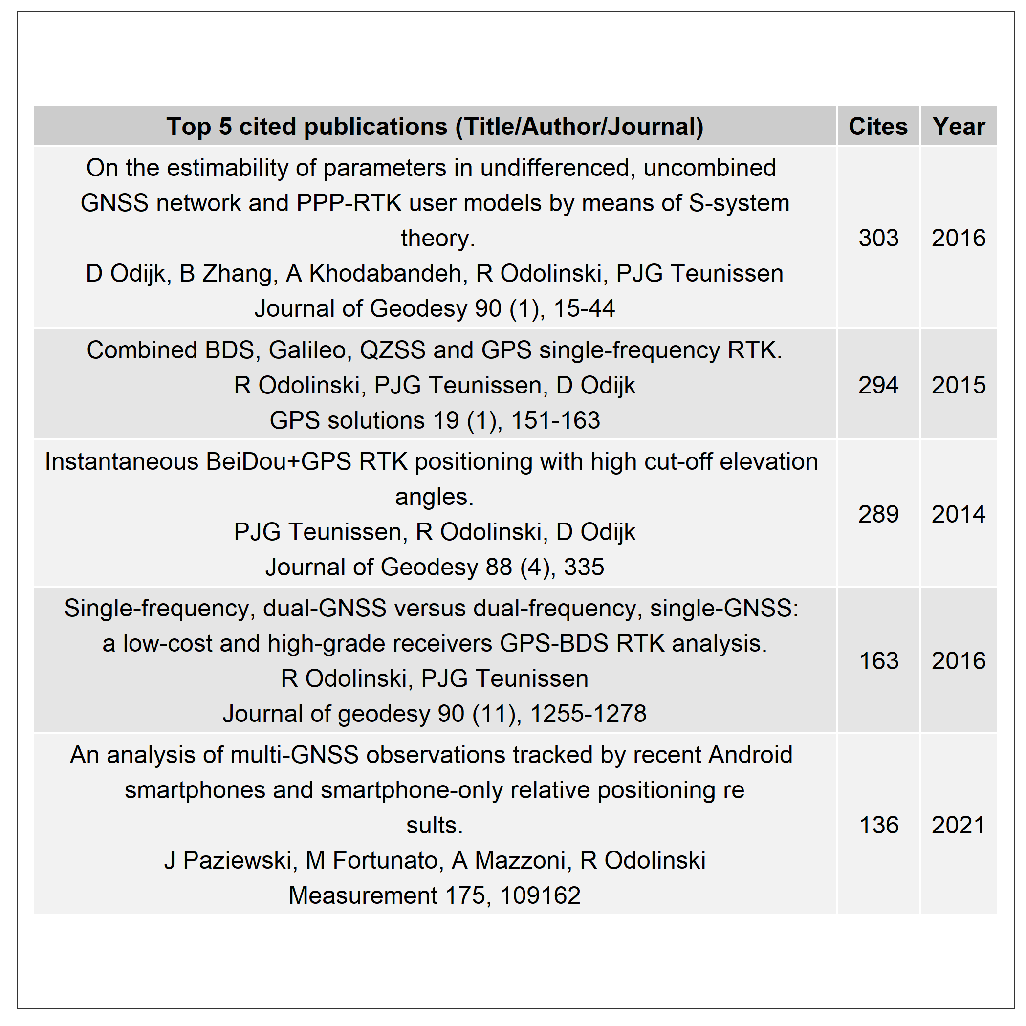
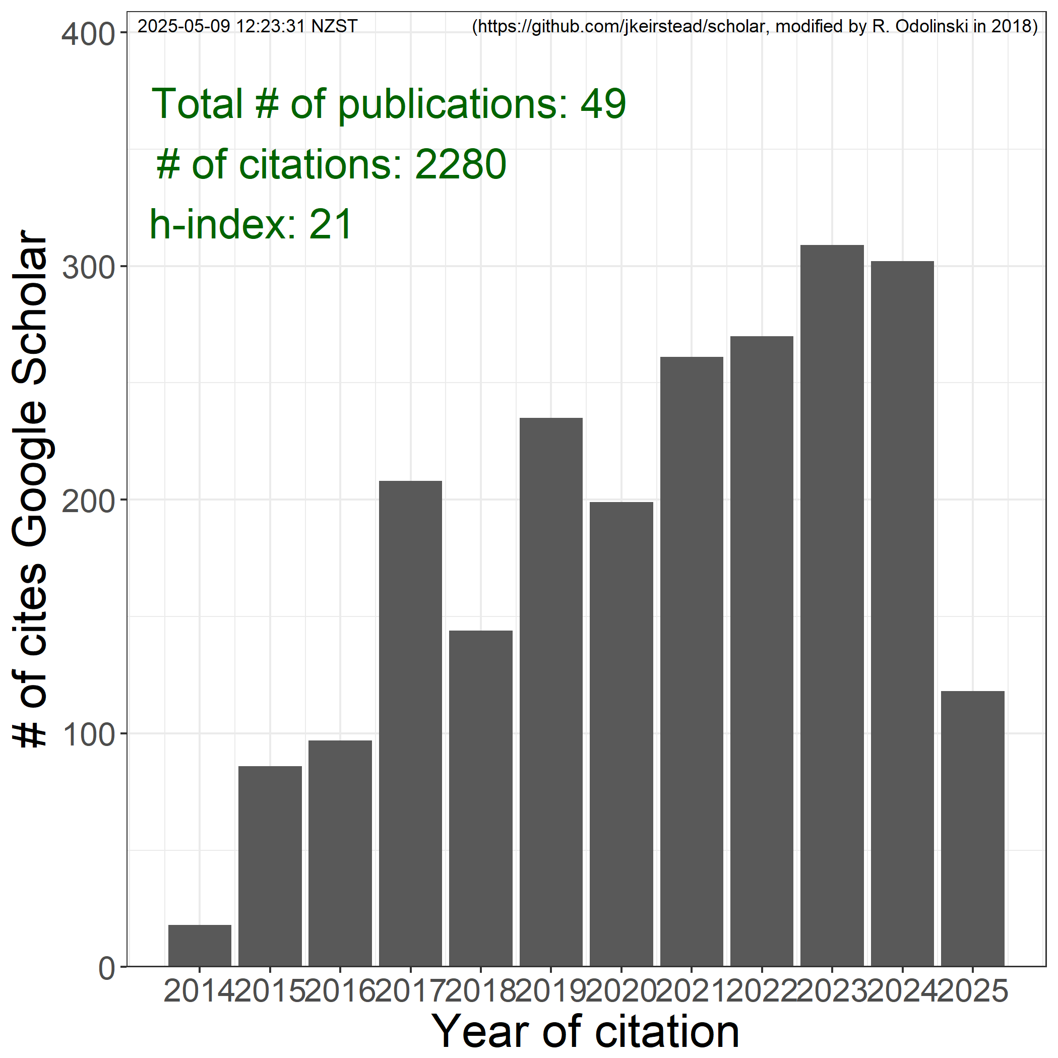
Research impact
Below figures are citation scores from Google scholar. My Web of Science statistics include more information such as ranking of citation scores, where I currently have the top 5% most cited articles in my field (in terms of age and type). Web of Science also give other measures, such as the percentage of corresponding/first author articles. My Scopus profile can also be found here.
Featured Project
Precise GNSS positioning with smartphones
Centimetre-level positioning in an Android smartphone using GPS/GNSS
GPS/GNSS positioning is one of the most used smartphone features traced back to 1999. This feature has been utilised by billions of smartphone users in the last few decades, primarily for meter-level navigation purposes. In recent University of Otago research, we show that it is possible to achieve centimetre-level positioning precisions with a mass-market Android smartphone. This research finding opens up a potential for accurate smartphone positioning in various applications, such as for autonomous vehicles, earth deformation monitoring, car lane keeping, construction engineering, surveying, etc.
Publications
Odolinski, R., Yang, H., Hsu, L.-T., Khider, M., Fu, G. M., & Dusha, D. (2024). Evaluation of the multi-GNSS, dual-frequency RTK positioning performance for recent Android smartphone models in a phone-to-phone setup. Proceedings of the International Technical Meeting of the Institute of Navigation (ION). (pp. 42-53). doi: 10.33012/2024.19575
Gao, R., Liu, Z., Odolinski, R., & Zhang, B. (2024). Improving GNSS PPP-RTK through global forecast system zenith wet delay augmentation. GPS Solutions, 28, 66. doi: 10.1007/s10291-023-01608-0
Still, H., Odolinski, R., Bowman, M. H., Hulbe, C., & Prior, D. J. (2023). Observing glacier dynamics with low-cost, multi-GNSS positioning in Victoria Land, Antarctica. Journal of Glaciology. Advance online publication. doi: 10.1017/jog.2023.101
Gao, R., Liu, Z., Odolinski, R., Jing, Q., Zhang, J., Zhang, H., & Zhang, B. (2023). Hong Kong–Zhuhai–Macao Bridge deformation monitoring using PPP-RTK with multipath correction method. GPS Solutions, 27, 195. doi: 10.1007/s10291-023-01491-9
Tidey, E., & Odolinski, R. (2023). Low-cost multi-GNSS, single-frequency RTK averaging for marine applications: Accurate stationary positioning and vertical tide measurements. Marine Geodesy. Advance online publication. doi: 10.1080/01490419.2023.2208289