The 2022 winter season brought some impressive avalanche cycles to the Southern Alps/Kā Tiritiri o te Moana. We are still sifting through all the data, but regions like Aoraki Mount Cook National Park had a very active winter--especially in July and August. After the record-breaking avalanche cycle documented near Mount Cook Village in mid-July, which was induced by heavy rain falling to high elevations, the snow kept falling.
We are busy combing through data from the Hooker Valley to compare the avalanche activity to previous years. We have already found some useful avalanche events that will help our work to better understand avalanche hazards in the Park.
You can read more about the ongoing research in the Hooker Valley here.
]]>We skinned up to the Pisa weather station to fix the snow depth and pressure sensors and install a new webcam at the site. Luckily, a couple of new wires, a fresh battery, and Todd's superb tinkering skills did the trick to get the sensors back up and running after a month of being offline. Prior to the snow depth sensor going out in August, the station recorded a whopping 53 cm of solid form H2O on the ground. By the time it was working again, only 13 cm remained! We hope that some of you took advantage of that peak accumulation period... The new webcam updates every 5 minutes between 6 am and 7 pm so that you can now watch the snow melt in (almost) real time!
You can access all of the station stats here.
]]>We headed over to Queenstown for some fieldwork on the Remarkables ski field and in Wye creek. We also met with members of the NZ Ski operations team to see if we could make use of snow depth data that their grooming machines collect each night. We also went for a night ski at Coronet Peak which was a great team bonding exercise!
We headed up the Remarkables bright and early to collect ground control points to help validate the elevation models we derive via SPM from Pleiades imagery tasked the week prior. We can also use this data to better understand snow depth measurements derived from SPM and the GPS units on the grooming machines. Moving through snow covered terrain made it most convenient for us to collect the positional data on skis! The skiiers (Aubrey, Charlie, and Ellorine) wore the GPS units on their backs while the snowboarders (Pascal and Todd) made sure expensive equipment wasn't dropped along the way. We collected profiles along some of the groomed runs on the ski field and then collected long transects in the Wye creek backcountry area.
]]>MRC team members headed to Wellington for two geospatial conferences, GeoCart and the NZ Geospatial Research Conference (GRC), where we shared some of our work with fellow academics and industry professionals. At GeoCart, Todd presented his work on mapping snow depth with Satellite Photogrammetric Mapping (SPM) and Aubrey shared his work mapping avalanche debris and modelling avalanche paths around the Milford Road and in Aoraki/Mt Cook National Park using imagery from the Planet constellation. Ellorine competed in the Young Geospatial Scholar competition, giving a talk on measuring landslide driven ground displacements with computer vision. At GRC, Pascal gave a lightning talk overview about the Matariki project and some of the areas where SPM is proving effective.
]]>NeSI (New Zealand eScience Infrastructure) recently wrote about the Matariki Project and how we are using their Mahuika supercomputer to scale up Satellite Photogrammetric Mapping (SPM) across the Southern Alps. NeSI resources enable us to process over 5,000 km2 of stereoimagery in Aoraki/Mt Cook National Park and Titiea/Mt Aspiring National Park to map the spatial and temporal distribution of snow and ice, and on the West Coast to detect landscape change driven by landsliding and glacial retreat.
Read more here.
]]>We attended the inaugural Fox Glacier - Te Moeka o Tūawe Research Workshop, a meeting designed to bring together people with various interests in the Fox and Franz Glacier areas. The workshop included researchers from University of Canterbury, University of Otago, University of Victoria - Wellington, and Massey University, as well as contingents from GNS Science, Fox Glacier Guides, and DoC. The first day was spent presenting research, observations, and experiences in the area and brainstorming ways to collaborate on fieldwork and share data and findings. Pascal shared his work on the Matariki Project, showing 3-D changes in the Fox catchment derived from Satellite Photogrammetric Mapping (SPM) driven by landslides, glacier retreat, and riverbed migration. Ellorine showed her work on the Alpine Gardens landslide studying the displacement of surface features using computer vision. Several researchers shared their work with the public at a community meeting held later that night. The next day we took a field trip to the GNS monitoring site on Cone Rock adjacent to the large alluvial fan fed by the Alpine Gardens landslide.
]]>We took advantage of a couple good autumn weather windows and travelled to the West Coast to collect ground control and survey a portion of the Fox River floodplain.
On our first trip at the end of April, we climbed Mt Fox and collected two static gps points from the summit and a lower ridge. These points will be used to assess the accuracy of several high-resolution DEMs we have constructed as part of the Matariki Project using Satellite Photogrammetric Mapping (SPM) techniques and Pléiades/Pléiades Neo satellite imagery. The 20 minutes needed to collect each point gave us plenty of time to take in the spectacular scenery of this rapidly evolving landscape. On the next day, we attempted to retrace our footsteps (literally!) surveying the Fox riverbed below the SH6 bridge. Last year, the team conducted a post-processing kinematic (PPK) survey to map countours of the braided floodplain. Collecting the same points a year later enables us to create precise 3-D change models and assess the sensitivity of our satellite-derived DEMs and resulting DEMs of Difference (DoDs). However, early on in our survey, we found that the river had changed course (unsurprising for a dynamic braided river) and we could not cross it on foot to access the rest of the survey points. Lucikly, Ellorine had an idea...
Two weeks later, we were back on the West Coast for the Fox Glacier - Te Moeka o Tūawe Research Workshop. This time, Ellorine brought along her whitewater kayak to cross the channel to finish the riverbed mapping. After crossing she continued collecting points before encountering another uncrossable braided channel... Having mapped a good portion of the contours, we decided to call it a day and headed back into town before the first raindrops of a big nor'wester started to fall. The weather window can't last forever!
]]>It was a busy summer for the Hooker Glacier terminus. Check out some of the images from one of our timelapse cameras on the ground as well as what the change looked like from space. The timelapse images are from October 1, 2022 (left) and April 9, 2023 (right). Images best viewed on a computer.
Intense rain episodes on the West Coast this month generated several large landslides and many significant rockfalls in the Aoraki/Mt Cook National Park.
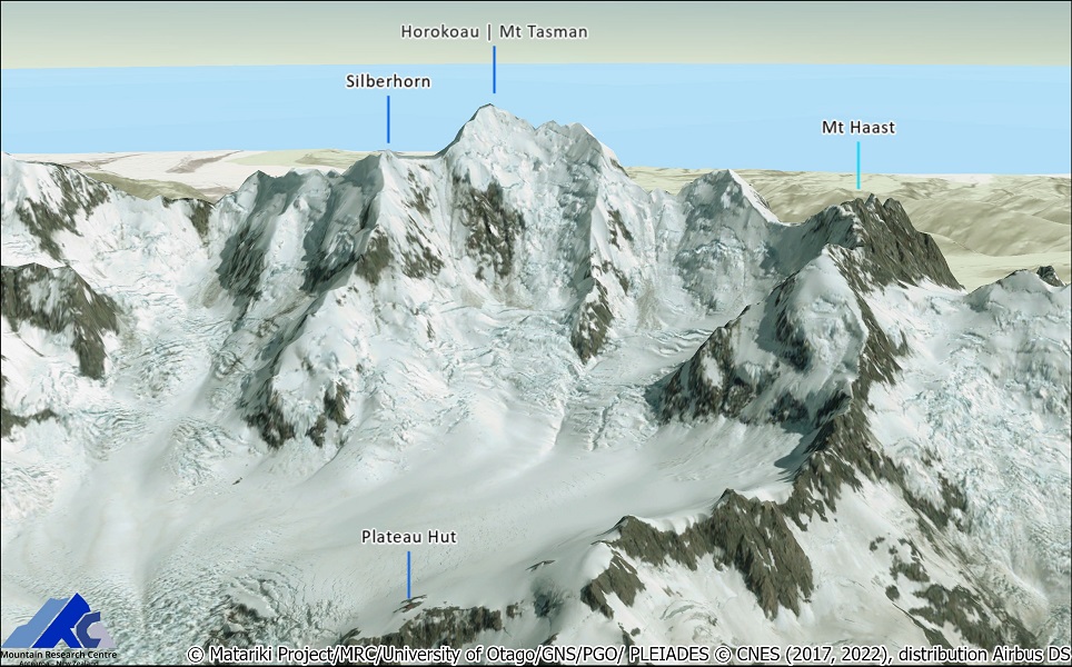
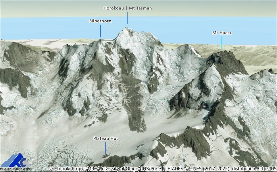
Thanks to the Pléiades Glacier Observatory (PGO), we've been lucky to obtain a new stereo acquisition as the weather cleared up on 8 February 2022 that captured numerous large landslides and rockfalls.
This was the first real-life test for the Matariki project, launched in 2019, which aims to transform environmental monitoring by using repeated high-resolution, automated, satellite mapping of landscape change.
As our automatic processing pipeline was now deployed on New Zealand supercomputing facility (NeSI), we succeeded in providing an up-to-date topography and a current look of the dramatic alpine landscape Within 24 hours to help DoC assess the extent of hazards and potential risks to park visitors.
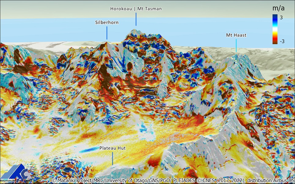
The work not only reveals the extent of the landslides, one of which is 704,000 cubic metres, with a runout distance of over a kilometre, but quantifies the unabated demise of glaciers, a high number of previously unknown landslides, and sometimes staggering changes to this iconic landscape.
Researchers get faster, better images of landslides | Stuff....
]]>MRC is leading a new collaborative project that seeks to improve the modelling of seasonal snow and catchment processes. The three-year project has received funding of 733,000 from the Deep South Challenge: Changing with our Climate, and will be led by Associate Professor Nicolas Cullen, in collaboration with Te Herenga Waka-Victoria University of Wellington and the National Institute of Water and Atmospheric Research.
It will leverage remote sensing expertise developped within MRC with the Matariki project to develop new snow observations, in particular derive and monitor snow depth from satellites.
Read the full University of Otago media release, see the project featured on Tv3 Newshub below, and listen to Drs Lauren Varo and Todd Redpath interview by Bryan Crump on RNZ.