General items
This page contains various interesting items.
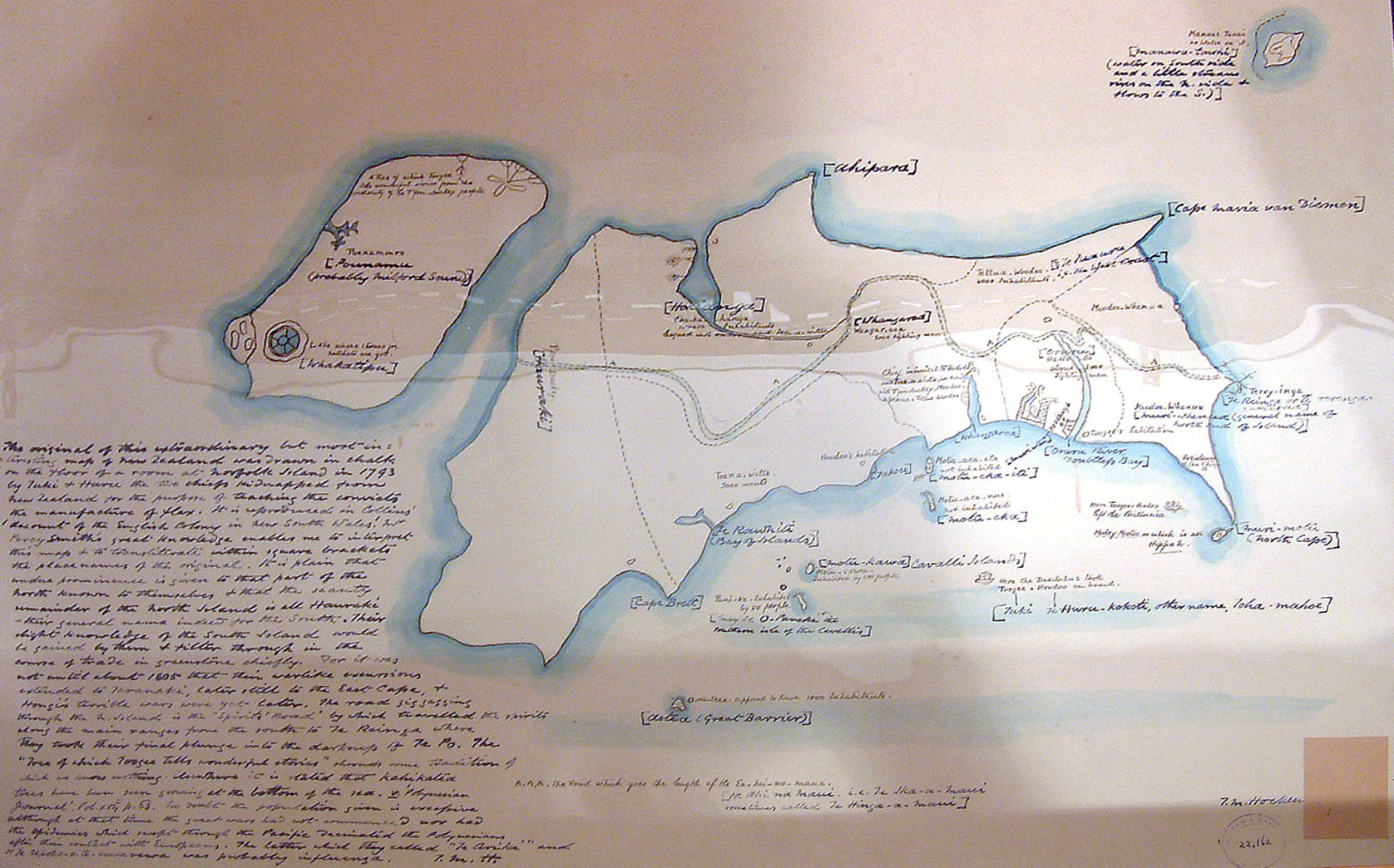
Reproduced Map of New Zealand originally drawn in chalk on the floor by two Maori Chiefs, Tuki Tahua and Ngahuruhuru, at Norfolk Island, 1793. HmapHM 830/1793/a, Hocken Library.
In May 1793, Tuki Tahua and Ngahuruhuru, two Northland Maori chiefs were kidnapped and taken on board the ship Daedalus. These young chiefs were kidnapped for the purpose of teaching convicts on Norfolk Island the techniques for manufacturing flax. Tuki and Ngahuruhuru stayed on Norfolk Island from May to November in 1793. By all accounts they were treated as guests by Lieutenant-Governor King, lived in Government House, ate at the Governor's table and were excused from manual labour.
Unfortunately, relatively little information about working with flax was passed on. This was due to the poor quality of Norfolk Island flax and the fact that flax manufacturing within Maori society was a skill, which women traditionally mastered.
However, the most remarkable achievement of the kidnapping was the production of Tuki's map; a unique record of Maori thinking. The map was originally drawn in chalk on the floor in Government House. Other maps were produced in this early contact period, but Tuki's is unique because it includes social, mythical and political information written at his dictation.
Two significant features of Tuki's map are the 'spirits' pathway' (Te Ara Whaanui) running the length of the North Island to Te Reinga (Cape Reinga) the spirits' place for leaping off into the underworld; and 'Poenammoo' (Te Wai Pounamu -The South Island) identified with information about two important natural features, a tree and a lake - presumably the greenstone waters of Te Waipounamu.
This is a reproduction of Tuki's map; the original is held in the Public Record Office in London.
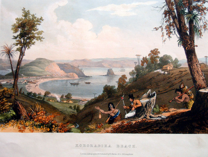
Augustus Earle, Sketches Illustrative of the Native Inhabitants and Islands of New Zealand. London: Lithographed & published under the auspices of the New Zealand Association by Robert Martin, 1838. Bliss, OEB Ear, Hocken Library.
Augustus Earle (1793-1838) visited New Zealand during October 1827 and May 1828. He was the first trained artist to visit New Zealand and reside for any length of time among the Northland Maori. His paintings, those that survived a fire in Australia in May 1828, form a remarkable commentary on early New Zealand. They not only depict the beauty of the country but also his appreciation of the Maori, whom he much admired. This is his sketch of Kororareka Beach.
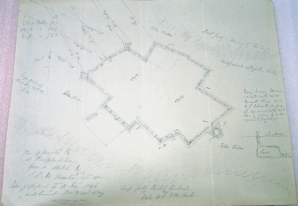
Ruapekapeka, Plan of Kawiti's Pa, near the Bay of Islands, 1846. Pictorial Collection, Hocken Library.
Ruapekapeka Pa was purpose built by Te Ruki Kawiti and Hone Heke and specially tailored and designed to counter European warfare. In contrast to traditional pa, Ruapekapeka pa had no direct strategic or economic importance. It did not guard borders, command important routes of communication, or protect cultivations. Unlike the traditional pa, this new purpose built pa at Ruapekapeka had virtually no inherent value and could be abandoned without qualm.
In 1853 Captain T.B. Collinson wrote this of the Battle at Ruapekapeka;
"1100 men were occupied a full month in advancing 15 miles and in getting possession of a pah from which the enemy escaped at the last moment, and escaped with the satisfaction to him of a drawn battle. The question is, was it worthwhile to go through all that laborious march to obtain such a result."
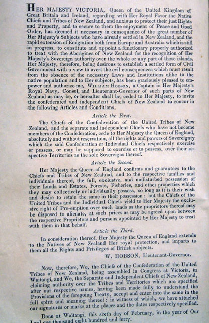
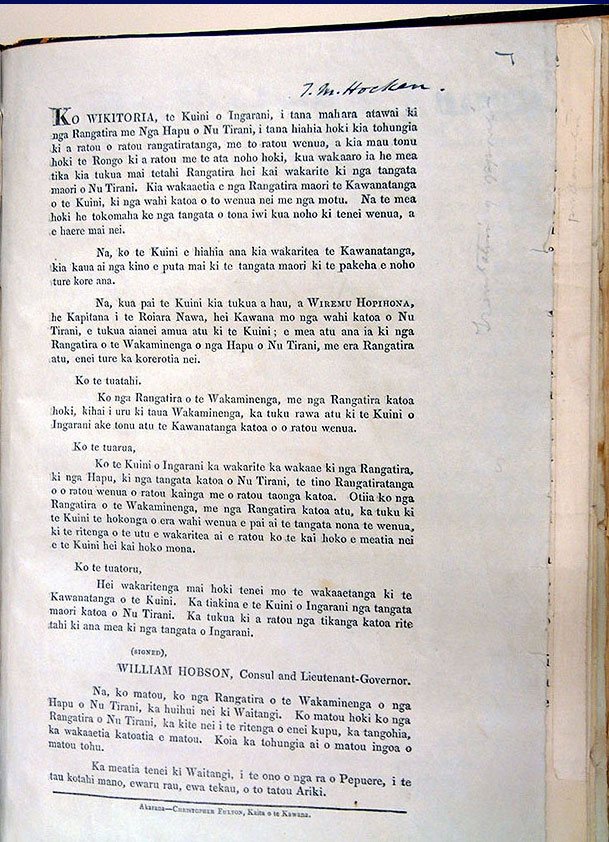
The Treaty of Waitangi (1844), Williams Collection 114, in Variae 4, 'Proclamations', No.7c. English version (left), Maori version (right), Hocken Library.
This is the first separate bilingual printing of the Treaty of Waitangi, and it follows the first printed version of the English text (accompanying the Maori text) that appeared in 1841. The Treaty was first signed on 6 February 1840. There are nine copies of the Treaty extant: the one originally signed at Waitangi and eight other signed copies, including one that is printed. All contain the names of chiefs (together with their signatures, moko or marks) who wished to signify their agreement to the treaty.
Christopher Fulton printed this copy in November 1844. Of the fifty printed, only four are extant, housed at the Auckland Public, Auckland War Memorial Museum, and Alexander Turnbull Libraries, and at the Hocken Library.

Waka. Shortland Papers, MS 489/1, Hocken Library.
This humble waka image was found tucked into the back of papers collected by Edward Shortland in the 1840s. There is no information recorded about this waka. The words that appear in the left hand corner are all that is documented. 'Waka Taua, He Tararo' ~ Adorned war canoe.

