Iongairo
Mapping Subtidal Habitats of Te Pātaka o Rākaihautū (Banks Peninsula)
The project name, Iongairo, was gifted by the Papatipu Rūnanga, and represents the relationship between Papatūānuku and Tangaroa – the first knowledge of the meeting of land and sea; or another way of interpreting ki uta ki tai, from the mountains to the sea.
Partners
Iongairo is a collaboration between Environment Canterbury, the Department of Conservation, and Ōnuku, Rāpaki and Wairewa Rūnanga, who are all seeking to better understand the distribution, functioning, and health of subtidal ecosystems around Te Pātaka o Rākaihautū/Banks Peninsula.
The University of Otago Marine Science Department and Mountain Research Centre have been contracted as the science provider for Iongairo, and will be working alongside the partners to help achieve their goals.
Find out more about the Iongairo project...
- Iongairo partnership makes waves in mapping the seafloor...
- Beneath the surface – Banks Peninsula seabed mapping...
Marine data and products
The primary output of this project is the production of a broad-scale habitat map that details the distribution of physical and biological structures/ecosystems in order to better inform managers. A key aspect of this project is to visualise and assess the connectivity between terrestrial and marine environments in order to reinvigorate management initiatives that acknowledge this important linkage.
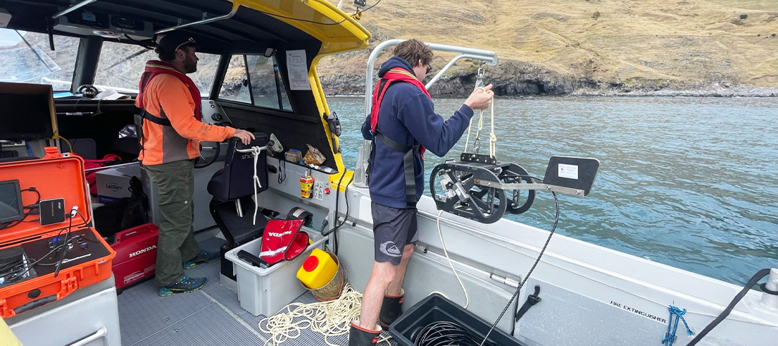
Multibeam survey data collected during the summer of 2021/22 by DML ltd will form the basis of the map, complemented by significant ground-truthing of seafloor features that will allow the distribution of key habitats and ecosystems to be modeled. The goal is to deliver end-user focused products that meet specific management, science, rūnanga, customary fisheries, community, and statutory planning needs.
Landscape change
Another focus of the Iongairo project is to understand the impacts of anthropogenic activities and large-scale drivers of change on the subtidal habitats and ecosystems around the Peninsula, and how the resulting impacts could influence ecosystem and fisheries management. The data and knowledge gained through this project will provide a foundation to inform decisions for years to come.
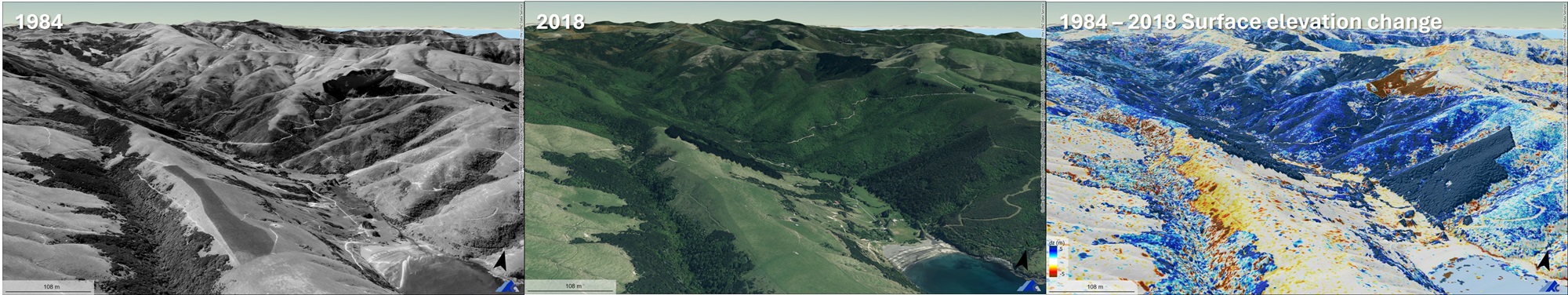
In this context, we leverage processes and methods developed by the Matariki project (MAtariki Photogrammetric MAPping and 3-d change Detection system, MAP23D) to produce and provide user-friendly means to visualize and interpret 3D-Change detection. A lidar dataset captured in 2023 (Landpro Ltd) is compared with another lidar survey acquired in 2018 (Aerial Surveys Ltd) to reveal recent patterns and magnitude of surface elevation change. A high-resolution photogrammetric reanalysis of aerial photos captured in 1984 (NZAM) will complete this assessment to reveal long-term landscape change across Te Pātaka o Rākaihautū/Banks Peninsula.
These 3D reality capture and change detection products can be visualised interactively in the Matariki 3D-CD WebApp below (login applies).
Reports
Pdf reports are better downloaded (right-click hyperlink/Save Link as...) and opened in Adobe Acrobat Reader.
In mountains we trust.