We took advantage of a couple good autumn weather windows and travelled to the West Coast to collect ground control and survey a portion of the Fox River floodplain.
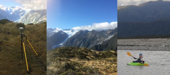
On our first trip at the end of April, we climbed Mt Fox and collected two static gps points from the summit and a lower ridge. These points will be used to assess the accuracy of several high-resolution DEMs we have constructed as part of the Matariki Project using Satellite Photogrammetric Mapping (SPM) techniques and Pléiades/Pléiades Neo satellite imagery. The 20 minutes needed to collect each point gave us plenty of time to take in the spectacular scenery of this rapidly evolving landscape. On the next day, we attempted to retrace our footsteps (literally!) surveying the Fox riverbed below the SH6 bridge. Last year, the team conducted a post-processing kinematic (PPK) survey to map countours of the braided floodplain. Collecting the same points a year later enables us to create precise 3-D change models and assess the sensitivity of our satellite-derived DEMs and resulting DEMs of Difference (DoDs). However, early on in our survey, we found that the river had changed course (unsurprising for a dynamic braided river) and we could not cross it on foot to access the rest of the survey points. Lucikly, Ellorine had an idea...
Two weeks later, we were back on the West Coast for the Fox Glacier - Te Moeka o Tūawe Research Workshop. This time, Ellorine brought along her whitewater kayak to cross the channel to finish the riverbed mapping. After crossing she continued collecting points before encountering another uncrossable braided channel... Having mapped a good portion of the contours, we decided to call it a day and headed back into town before the first raindrops of a big nor'wester started to fall. The weather window can't last forever!