Interactive map
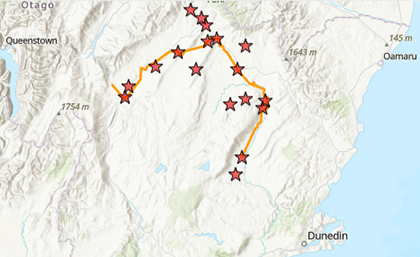
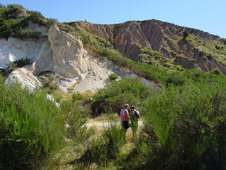
The map linked below shows the Otago Central Rail Trail route between Clyde and Middlemarch. More information is available for the locations marked by stars.
Interactive map of the Otago Central Rail Trail
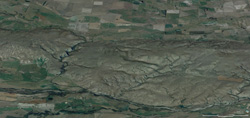
The circuitous path of the Taieri river in East Otago
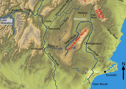
The Taieri river drains only the eastern Otago uplands, and follows an almost circular path from its source to the sea. The Taieri River discharges to the Pacific Ocean at Taieri Mouth, only 60km from its source area in the Lammermoor and Lammerlaw Ranges.
Evaporative salts in Central Otago
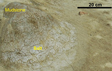
The combination of high temperatures, low rainfall, and wind-driven evaporation has resulted in localised accumulation of evaporative salts in inland parts of Otago, and Central Otago in particular.
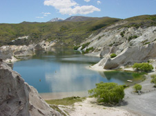
Sutton Salt Lake
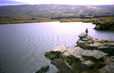
The Sutton Salt Lake is the only saline lake in New Zealand, and has formed in a windy cool-temperate maritime climate. Consequently, the lake is distinctly different from most of the world's saline lakes that form in arid continental settings.
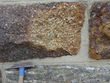
Hyde – Eocene quartz gravels
On a regional scale, the gold-bearing gravels occur close to the Waipounamu Erosion Surface. The Eocene gravels are immediately below the erosion surface, and rest on the basement unconformity.
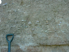
Tiroiti – sediments below the Waipounamu Erosion Surface
Fluvial (river) sediments immediately beneath the Waipounamu Erosion Surface typically grade upwards into estuarine sediments and then to fully marine sediments at the erosion surface.
Naseby – Alluvial gold recycling
Gold from both Eocene and Miocene gravels has been recycled by erosion during fault-related uplift between Pliocene (2-5 million years ago) and Recent. This recycling process can result in dilution of the gold content by eroded basement material.
North Rough Ridge – Waipounamu Erosion Surface today
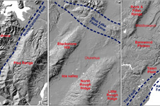
The Waipounamu Erosion Surface is now visible in the topography of East and Central Otago as broad areas in which the basement surface is essentially flat, with minor dissection by active rivers and streams
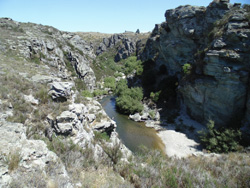
Ida Burn gorge – River drainage redirection
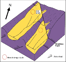
The intersection of NW- and NE-trending active structures along the Hawkdun Fault Zone in central Otago has resulted in uplift of the synformal (down-folded) basins in the complex structural zone.
Oturehua – Gold-bearing veins at Oturehua
There were two principal stages of gold mineralization in the Otago Schist basement: Jurassic-early Cretaceous, as at Macraes, and middle Cretaceous. The vein system at Oturehua is part of the latter group.
Pennyweight Hill – Alluvial gold along the northeast Otago margin, Miocene quartz gravels
The Miocene gravels (Dunstan Formation) in Central Otago rest on the Miocene unconformity which is close to the Waipounamu Erosion Surface.
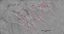
Fiddlers Flat – Blue Lake Fault Zone, Regional setting
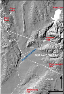
The Blue Lake Fault Zone occurs at a major crustal boundary between Otago Schist and Torlesse greywacke, on the northeast margin of the Otago Schist belt.
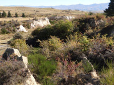
St Bathans and Blue Lake
Blue Lake, at the foot of Mt St Bathans in Central Otago, is one of several important historical gold mines in the area. Mt St Bathans is made up of 200 million year old greywacke and that continues deep under the Blue Lake area.
See also DOC page on the history of St Bathans
Patearoa gold: Alluvial concentrations in a dynamic environment
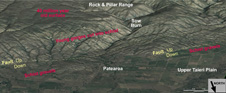
Patearoa is an historic gold mining area on the southern edge of the Maniototo Basin. The goldfield lies on the northern slopes of the actively rising Rock & Pillar Range, near to the historic Hamiltons Diggings alluvial gold mining area. The gold at Patearoa has been concentrated in gravel deposits (=alluvial gold) that accumulated in alluvial fans on the slopes of the actively rising Rock and Pillar Range.
Hamilton Diggings
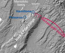
Hamilton's Diggings has some remnants of 40 million year-old quartz gravels, and 20 million year-old quartz gravels occur on the west side of the Maniototo valley. These quartz gravels contain abundant gold, especially where they rest on the schist.
Gold at Alexandra
The most prominent feature of the faulted zone in the Raggedy Range is Tucker Hill, between Galloway and Alexandra. This relatively rugged valley wall contrasts strongly with the gentle slopes of the northeastern and central portions of the Raggedy Range.
Gold at Ophir
The southern portion of the Raggedy Range has been made more complicated by the presence of a set of faults at the margin of the valley. The faults are geologically ancient, but some of these faults have acted as weak zones during the present folding of the region.
Poolburn gorge
The smooth gentle slopes of the Raggedy Range reflect the folded structure of the schist bedrock, and this fold is still developing as the range rises. The rising range has forced the Poolburn to cut a deep gorge through the range, through which the rail trail passes.