MSc (Colorado State University, USA)
BA (Hons)(The College of William and Mary, USA)
Email aubrey.miller@otago.ac.nz
Tel +64 3 479 7606
Location: School of Surveying, 310 Castle Street, Room 118
Profile
I am a Senior Professional Practice Fellow in geospatial science in the School of Surveying. I have lecturing and lab co‑ordination responsibilities for the geospatial papers. I also manage the spatial computer lab and provide research support to students and staff. I conduct research in the areas of GIS, natural hazards, outdoor recreation and spatial ecology. My primary research focus currently is my PhD project on snow avalanche hazards in Aotearoa New Zealand.
Teaching
- SURV 120 Surveying and Spatial Science (contributor)
- SURV 220 Introduction to Geographic Information Science
- SURV 309 / SURV 509 Introduction to Remote Sensing (contributor)
- SURV 319 / SURV 519 Spatial Algorithms and Programming (contributor)
- SURV 411 / SURV 511 Advanced Spatial Analysis and Modelling (contributor)
- SURV 412 / SURV 512 Geovisualisation and Cartography (contributor)
- MARI 322 Coastal and Shelf Seas Oceanography (contributor)
- MARI 401 Advanced Methods in Marine Science (contributor)
- ECOL 111 Ecology and Conservation Diversity (contributor)
GIS Software short-courses for Otago staff and postgraduates, offered annually in February: Intro to ArcGIS Desktop, Intro to ArcGIS Pro, Intro to QGIS (coordinator).
Email aubrey.miller@otago.ac.nz for more information.
Research and professional interests
- Geographic Information Systems (GIS)
- Geospatial analysis
- Natural hazards, in particular in alpine regions
- Snow avalanches
- Outdoor recreation
- Remote sensing
- Photogrammetry and lidar
- Terrain analysis and modelling
- Bathymetric analysis
- Spatial ecology
- Geovisualisation
- Volunteered Geographic Information / Participatory GIS
I am a member of the Coastal People: Southern Skies collaboration that connects communities with world-leading, cross-discipline research to rebuild coastal ecosystems.
Coastal People: Southern Skies
![]() I am a member of the Mountain Research Centre at the University of Otago. We focus on conducting high-value research in mountain systems, with a focus on climate, snow & ice, natural hazards and society.
I am a member of the Mountain Research Centre at the University of Otago. We focus on conducting high-value research in mountain systems, with a focus on climate, snow & ice, natural hazards and society.
Mountain Research Centre
Some current and recent projects
Iongairo: Te Pātaka o Rākaihautū, Banks Peninsula habitat mapping (2022–ongoing)
We are the science partner for a collaborative partnership between papatipu rūnanga of Te Pātaka o Rākaihautū, the Department of Conservation and Environment Canterbury (ECan) that is investigating subtidal habitats and ecosystems on the Banks Peninsula. Read more from ECan website:
Iongairo: Partnership makes waves in mapping the seafloor – Environment Canterbury
Snow avalanche hazards in Aotearoa New Zealand (2020–ongoing)
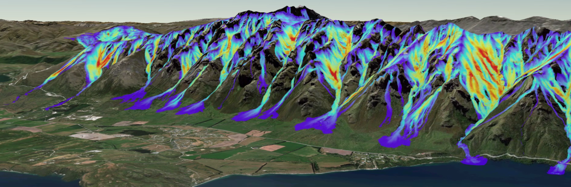
This project, a collaboration between Otago University and WSL-SLF in Switzerland, uses the latest advances in topographic mapping, remote sensing and modelling tools (e.g. RAMMS) to improve our understanding of snow avalanche hazards in New Zealand. Avalanche Hazard website
Matariki: Quantifying environmental resources through high-resolution, automated, satellite mapping of landscape change (2019–2023)
The Matariki project is funded by MBIE Endeavour Smart Idea to transform environmental monitoring by quantifying environmental resources through high-resolution, automated, satellite mapping of landscape change. This project will develop a novel way to make 3D-change maps with unprecedented detail and sub-metre accuracy.
Source to Sea: A scientific investigation of the local catchment for Dunedin region rural schools (2018–2021)
This is a collaboration with the Halo Project, with funding from the Curious Minds Initiative, to help local students understand biodiversity, land use and water quality in their local catchment.
Halo Project website
Students embark on physical and virtual field trips to better understand their catchments, including with the use of a GIS. You can see examples of the webGIS students are using to study their catchments in the scene below or by visiting this site: Land Use Change Source to Sea
Community mapping of historical land use on Mahu Whenua Covenants land, Central Otago, New Zealand (2017–ongoing)
This is a Catchments Otago Project (PI Tony Moore) that aims to capture local knowledge of historic land use in the four farms that make up the Mahu Whenua Covenants land between Arrowtown and Wanaka. We have conducted interviews with farmers and locals with a connection to the land reaching back to the 1950s and captured the knowledge on a series of maps that will be combined in a GIS.
Glaciers in the picture: How much have New Zealand glaciers changed over the last 30 years? (2017–2018)
This is a University of Otago Research Grant-funded project (PI Pascal Sirguey) measuring and mapping changes to NZ glaciers with recent satellite imagery and state-of-the-art photogrammetry techniques.
Recent student supervision
- Dylan Pollard (2023), MSc, “Modelling landscape permeability for the management of the common bushtail possum in west harbour, Otago New Zealand.” (co-supervisor)
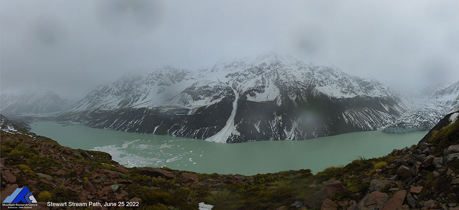
- Anna Smith (2021), BSc(Hons), “Satellite-detected snow avalanche debris in the Hooker Valley: forecasting ability and meteorological controls.” (co-supervisor)
- Leonardo Nava Jimenez (2020), PhD, “Recreational camping in New Zealand.” (advisor)
Responsibilities
School
- Spatial Lab manager
- Marketing Committee
- Undergraduate Committee
- Surveying Professional Year Mentor
- Convener: GIS@Otago Symposium (bi-annual)
More about the GIS symposium
Profession/Memberships
- Mountain Research Centre (MRC)
- Coastal People: Southern Skies Centre of Research Excellence (CoRE)
- New Zealand Institute of Surveyors
- Snow and Ice Research Group
- New Zealand Cartographic Society
Publications
Cox, S. C., Sirguey, P., Lewis, C. N., Carle, E., & Miller, A. D. (2023). Acceleration of landscape change in the Southern Alps during the past decade. In G. E. Frontin-Rollett & S. D. Nodder (Eds.), Geoscience Society of New Zealand Miscellaneous Publication. 164A, (pp. 54). Wellington, New Zealand: Geoscience Society of New Zealand. [Abstract] Conference Contribution - Published proceedings: Abstract
Miller, A., Jones, A., Smallwood, M., Bogie, D., Sirguey, P., Redpath, T., & Bartelt, P. (2023). Performance of the Kitchener path protection berm during the historic July 2022 avalanche cycle, Southern Alps, New Zealand. Proceedings of the International Snow Science Workshop (ISSW). (pp. 846-853). Retrieved from https://arc.lib.montana.edu/snow-science Conference Contribution - Published proceedings: Full paper
Sirguey, P., Cox, S., Redpath, T., Miller, A., & Carle, E. (2023, August-September). The Matariki project: Surveying and mapping landscape change with reality capture technologies. Verbal presentation at the Survey & Spatial New Zealand (S+SNZ) Annual Conference: Marking the Journey, Hāpaia, Dunedin, New Zealand. Conference Contribution - Verbal presentation and other Conference outputs
Miller, A. D., Redpath, T. A. N., Sirguey, P., Cox, S. C., Bartelt, P., Bogie, D., Conway, J. P., Cullen, N. J., & Bühler, Y. (2023). Unprecedented winter rainfall initiates large snow avalanche and mass movement cycle in New Zealand's Southern Alps/Kā Tiritiri o te Moana. Geophysical Research Letters, 50, e2022GL102105. doi: 10.1029/2022GL102105 Journal - Research Article
Sirguey, P., Miller, A., Carle, E., Cox, S. C., Redpath, T., & Cullen, N. J. (2022). The Matariki Project: 3-D change detection with satellite photogrammetric mapping. Proceedings of the New Zealand Geospatial Research Conference (NZGRC). Retrieved from https://geocollaboratory.massey.ac.nz/new-zealand-geospatial-research-conference-2022 Conference Contribution - Published proceedings: Abstract