Alan Cooper Inaugural Professorial Lecture September 18 2002
Introduction
The Geology Department's involvement in Antarctica began in the mid-1950s when a resurgence of interest in Southern Victoria Land (SVL), following the heroic era of Scott and Shackleton, was sparked by the International Geophysical Year and the Commonwealth Trans-Antarctic Expedition. Geologist Bernie Gunn completed a PhD at Otago, based on fieldwork in the Transantarctic Mountains related to the Ferrar intrusive rocks. Subsequently, the Geology Department's research involvement in Antarctica waned, until resurrected in 1986/1987 by Associate Professor Dave Craw. He instituted a postgraduate-based research programme intended to be shared by staff in Geology, who would take down a small number of students each year, working in SVL. The research was necessarily focussed in areas close to Scott Base so that logistical problems were minimised. In the years that followed, 6 staff became involved, with a seventh to follow this austral summer. In all, 27 student theses have been supervised, and collectively the Otago programme, to quote a recent referee of one of our research grant applications, has "rewritten the text book on the geology of southern Victoria Land". In this lecture I would like to tell you about some of the results of our research.
History Of Exploration
In late 1839-early 1840 Capt James Clark Ross in charge of two vessels, HMS Terror and HMS Erebus, sailed south from Hobart with the aims of recording magnetic observations at high southern latitudes and, if feasible, of reaching the South Magnetic Pole. Ross sighted land near Cape Adare in Northern Victoria Land (NVL), and observed the high peaks of the Transantarctic Mountains (TAM). He collected geological specimens from offshore islands, and sailed south into the Ross Sea, to the foot of Mt Erebus and the barrier of the Ross Ice Shelf. Whaling expeditions were to follow in subsequent years.
In 1899, a British-sponsored expedition, led by an Australian Carstens Borchgrevink, wintered over in NVL, and next year, on the Southern Cross sailed south to Ross Island, collecting samples of Tertiary volcanic rocks en route.
The major geological advances in SVL, however, were made in later expeditions led by Scott and Shackleton, first in 1901-4 on Discovery, then in 1907-9 on Nimrod, and finally the ill-fated Terra Nova expedition of 1910-13. As you all doubtless remember, it was Scott's insistence on retaining rock specimens collected on his return from the South Pole that may have contributed to his demise. I sympathise with his dilemma, all of the Otago field seasons have involved either the back-packing or man-hauling by sledge of rock specimens, with a constant temptation to offload surplus specimens into the nearest crevasse!
Geological Summary
So what of the geology of the Transantarctic Mountains? The mountain range itself extends across the Antarctic continent for a distance in excess of 3500 km, and comprises peaks over 4000 m high (Fig 1). One of the lasting impressions of SVL is the view from near Ross Island, where Scott Base and McMurdo Base are situated, of the majesty of the Transantarctic Mountains rising steeply from the Ross Ice Shelf. This segment of the TAM was named by Scott's party as the Royal Society Range, in recognition of the financial support for the expedition; many of the peaks carry the names of past presidents of that society.
|
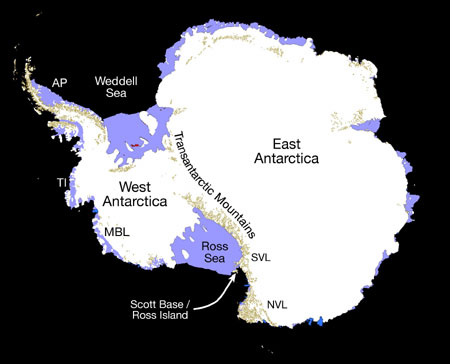
Fig.1 Map of the Antarctic continent showing the Transantarctic Mountains dividing East and West Antarctica. Localities referred to in subsequent diagrams include AP-Antarctic Peninsula, TI-Thurston Island, MBL-Marie Byrd Land. |
The Transantarctic Mountains divide Antarctica into two geological provinces. East Antarctica, the larger of the two, is geologically a very stable area, composed of very old rocks, which we refer to as a craton. In SVL, most of the craton is covered by ice of the Polar Plateau, but elsewhere the rocks have been dated as Archean, extending back in time to 2.5 Ga (2,500,000,000 years). In contrast, West Antarctica is composed of a collage of crustal segments, unrelated to the craton, and much younger. Effectively the TAM is a suture, dividing yet uniting the continent.
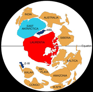
To answer the question of how the TAM was formed, we need to go back approximately 750 million years into the Precambrian period and then, according to ideas espoused by Moores and Dalziel, the East Antarctic craton used to form the nucleus of a land mass called Rodinia. Their idea, referred to as the SWEAT hypothesis, derives from SouthWestern U.S. East Antarctica, since the proponents believe that the best correlation of rocks from the margin of East Antarctica lie along the margin of the Laurentian craton of North America (Fig 2).
|
Fig. 2.A Reconstruction of the supercontinent Rodinia at ca 725 Ma (E-W- Ellsworth Whitmore, W.AFR-West African craton, KALAH-Kalahari craton). |
|
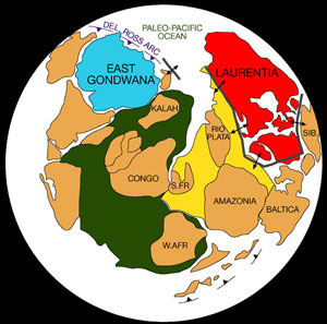
Fig. 2B. Reconstruction of Rodinia at the Cambrian-Precambrian boundary, showing subduction of the Paleo-Pacific ocean crust at the Delamerian-Ross convergent margin (S.FR-Sao Francisco craton, SIB-Siberia craton) |
Acceptance of mobility of crustal fragments around the surface of the globe, undreamt of in Scott's time, or even in the early years when I trained as a geologist (!), was made possible through the revolutionary Plate Tectonic concept. Rodinia is thought to have fragmented approximately 700 million years ago, North America drifting off to its place on the surface of the Earth, opening up an expanding ocean, the fore-runner of the Pacific Ocean perhaps, in its wake. Evidence for an old oceanic component on the edge of East Antarctica lies in suite of basalts of mid-ocean ridge character, dated at 668 Ma, now incorporated into the central sector of the Transantarctic Mountains.
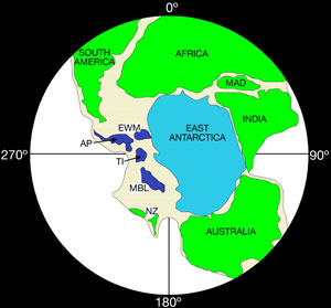
Subsequently, with successive plate readjustments, the paleo-Pacific Ocean closed, and the rifted margin of East Antarctica became a war zone. Here oceanic crust of the newly-opened Pacific Ocean was destroyed by subduction and any crustal fragments adrift in the ocean were rafted towards the subduction zone to collide with, and be accreted onto, the leading edge of the craton. Plate convergence, with associated subduction and collision, was responsible for uniting East and West Antarctica. The association of geological processes is referred to as the Ross Orogeny. An orogeny is a mountain building process, a time when there is upheaval of the earth's crust, with associated magmatic activity and metamorphism of any sediments that had formed in the ocean basin, or along its margin, and which were deformed and thermally altered on incorporation into the convergent plate margin. This convergence, occurring in latest Precambrian or Cambrian times, approximately 500 million years ago, is not unique to Antarctica. The same aged orogenic rocks occur in New Zealand (as part of Fiordland), and in Australia. The inescapable conclusion from these correlations is that Antarctica, New Zealand and Australia used to be part of the same margin, they were part of a single supercontinent, which is called Gondwanaland. Africa, South America, and India were also our neighbours (Fig 3).
|
Fig. 3. Reconstruction of Gondwanaland in the Early Mesozoic.(EWM-Ellsworth-Whitmore Mountains, NZ-New Zealand). |
It is these Ross Orogeny rocks that were later to become the so-called basement to the TAM. They are the oldest rocks exposed over much of the mountain range, and they have been uplifted, eroded, subjected to later orogenies, and overlain by later rocks.
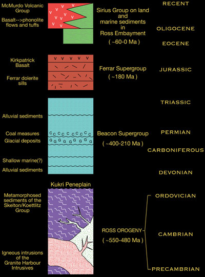
Throughout SVL the Ross Orogeny basement rocks have been eroded down over a long period of geological time (perhaps up to 100 million years), to form an almost planar upper surface, on which later rocks have been deposited. This surface, an unconformity, has been termed the Kukri erosion surface or peneplain. It is overlain by a vast (c 2.5 km thick) sequence of horizontally bedded sediments, dominated by quartz-rich alluvial sandstones and conglomerates, but containing Carboniferous glacial deposits and Permian coal measures. Collectively the sequence is referred to as the Beacon Supergroup (colloquially "Beacon Sandstone"), and is interpreted as having been deposited in elongate non-marine or at times shallow marine basins parallel to the present axis of the TAM. In SVL its age ranges from Devonian to Triassic, a period of nearly 200 Ma. Fossil fish and land vertebrates have been found, indicating establishment of fresh-water lakes at various stages of the sedimentary history.
The next event recorded in the geological history of SVL occurs over the length of the TAM and represents the intrusion of copious volumes (estimated between 1.0 and 1.7 x 10⁷ km3) of basaltic magma. This was injected into the basement and into the overlying Beacon Sandstone. The dominant form is of subhorizontal sheets, intruded into the basement, along the peneplain, and into the overlying sediments, where they define bodies called sills. Occasional discordant, steeply dipping intrusions called dykes connect the sill horizons. Individual sills often reach thicknesses of 420 m and can be traced, or extrapolated, over very large areas (>20000 km2). Because of the thermally insulating effect of large magma volumes, the sills cool slowly and form rocks called dolerites, rather than basalts. However, magmas are also injected to the Earth's surface and are erupted as lavas that cool more slowly and form the Kirkpatrick Basalt. Recent work within the Department has shown that some of these high level magmas react explosively with groundwater in the Beacon Sandstone and form extensive phreatocauldera. Basalts and dolerites are collectively referred to as the Ferrar Supergroup, named after H.T.Ferrar, geologist on Scott's Discovery expedition. Recent work has suggested that Ferrar magmas have such similar compositions that they must have been generated in a single, point-source, partial melting event in the mantle of the Weddell Sea area, and subsequently injected and magmatically transported up to 3000 kilometres along the length of the TAM.
Irrespective of whether the magmas are indeed far-travelled, it is clear that Ferrar magmatism marks a very important event in terms of its distribution. Igneous rocks have been isotopically dated, and as analytical accuracy and precision have improved, it is evident that the copious outpourings have occurred over a very short time frame in the Jurassic (177-183 Ma). What is more, similar magmatism occurs elsewhere in Gondwanaland, in Africa (the Karoo basalts), in Tasmania and New Zealand, and in the Falklands. Such Large Igneous Provinces (LIPs) are a characteristic consequence of, or precursor to, continental fragmentation.
In many theories, the impact of a deep mantle-generated plume or superplume onto the lithosphere is instrumental in the break-up of a supercontinent such as Gondwanaland. Plumes are considered to be a diapiric uprise, perhaps from the core-mantle boundary, of a vertical column of plastic rock. When the plume intersects the base of the lithosphere its head flattens out, dragging the lithosphere with it, and initiating plate spreading. If a superplume was responsible for the fragmentation of Gondwanaland, it is argued that the likely impact site would be the area of the present Weddell Sea.
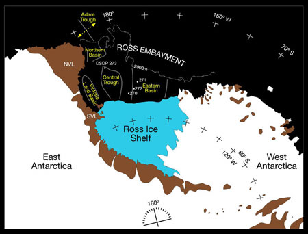
New plate boundaries were established during the dispersal of Gondwanan fragments, but until recently there has been considerable debate about whether a boundary still existed through the Antarctic continent. Through Deep Sea Drilling projects, through marine geophysical investigations, and through paleomagnetic observations we now know that the Ross Sea Embayment contains extensive sedimentary basins that have accumulated considerable thicknesses (up to 7 km) of Tertiary sediments. East and West Antarctica have also undergone at least 300 km of displacement and perhaps 40° to 90° of rotation in the last 100 Ma. Recently it was established that much of this separation occurred in the Eocene and Oligocene, related to spreading in the Adare Trough at the mouth of the Ross Sea Embayment (Fig 4).
|
Fig.4. The Ross Sea area showing the Transantarctic Mountains, the offshore sedimentary basins of the Ross Embayment, and location of Eocene-Oligocene spreading in the Adare trough. |
Fission track dating had established many years earlier that uplift of the TAM started approximately 55 Ma ago. The documented extension and subsidence of the crust in the Ross Embayment is compatible with complementary uplift of the Transantarctic Mountains on the western shoulder of this rift system. As such, uplift of the TAM occurs by normal faulting, in marked contrast to the collisional events at convergent margins typical of other mountain belts around the world (e.g. Himalayas, European and New Zealand Alps etc).
Extensional Tertiary sedimentary basins received the erosional debris from the rising TAM, and the extension is also manifest in one other concurrent geological phenomenon, namely magmatism. Volcanic rocks were erupted in NVL from 48 Ma (Eocene) and in SVL from 24 Ma (Oligocene) to the present day. Mt Erebus, formed as a consequence of this magmatism, is the most southerly active volcano on Earth.
Climatic deterioration occurred in the late Tertiary, but fine details of the glacial chronology and the extent of the glaciations are still uncertain. Resolution of these issues is the subject of multi-national drilling incentives (e.g. ANDRILL) at the present day. The geological history of SVL is summarised in the attached stratigraphic column (Fig 5).
|
Fig. 5. Stratigraphy of Southern Victoria Land. |
Geology Of Southern Victoria Land
The Otago programme investigating the basement terrain formed during the Ross Orogeny has had to deal with a variety of mainly plutonic igneous rocks intruding into and inducing contact metamorphism of a metasedimentary sequence of uncertain age.
Further south, sediments include fossiliferous, archeocyathid-bearing limestones, enabling a biostratigraphic age of Cambrian to be assigned. In SVL the grade of metamorphism of calcareous and calc-silicate sediments is reasonably high, and any fossils have been destroyed by metamorphic recrystallisation. Ages of the parent rock type (protolith) are therefore unknown.
Intrusive igneous rocks had been mapped and classified previously on the basis of either the presence or absence of a foliation (a planar mineral fabric such that a rock splits into parallel-sided slabs) or their colour (pink, grey, etc.). Those granites where the individual grains have a parallel alignment to form a foliation, were inferred to have been recrystallised by a metamorphic event subsequent to intrusion and were designated as pre-tectonic. Those that were non-foliated were assumed to have been unaffected by metamorphism, and hence were post-tectonic. Unfortunately this scheme doesn't work, as our first batch of post-graduate researchers quickly found out. The policy was adopted instead, of mapping the basement igneous rocks as separate intrusions (or plutons). The practice was labour intensive in the field, but using field relationships it gave rise to an unambiguous relative age for each pluton. The presence of fragments of one type of granite enclosed within another clearly indicated that the fragments belonged to an earlier pluton that had been broken off and entrained into a later intrusion. Similarly, an igneous intrusion such as a dyke, emplaced across another igneous body is clearly later.
Geochemical analysis back in the laboratory resulted in an additional chemical classification of the granite. These first studies, conducted on granites in the Dry Valleys area, were instrumental in defining different igneous suites, whose chemical characteristics were broadly compatible with formation in a convergent, plate-margin environment, above the previously inferred subduction zone where the paleo-Pacific Ocean crust was consumed beneath the East Antarctic craton.
As the programme evolved, it became clear that in order to make regional correlations and to constrain the duration of the Ross Orogeny we needed absolute ages on specific plutons in order to define the timing of intrusion of the various suites. Given that K-Ar dating gives uplift rather than intrusive ages, and is susceptible to resetting by subsequent thermal events, we opted to try U-Pb dating instead, which is potentially a more robust chemical system.
U is a radioactive element, with238U decaying with time to206Pb, and235U decaying to 208Pb. U is an element that is accommodated into the crystal structure of the mineral zircon, ZrSiO4. Zr, in turn, is an element that occurs in some abundance in the continental crust, so is concentrated in granitic magmas formed by melting of crustal materials. Zircon is a highly refractory, physically resistant mineral, which, once formed, is difficult to destroy and it requires exceedingly high temperatures to recrystallise or modify the stored age signature within a chemically zoned grain. Zircon is separated from crushed granites using density and magnetic properties, and suitable grains are then chemically treated to isolate the appropriate elemental concentrates. Isotope ratios are determined by Thermal Ionisation Mass Spectrometry, and an age calculated. All of this U-Pb geochronology has been undertaken in collaboration with scientists Drs Dave Parkinson and Nick Walker who have access to overseas facilities at UCSB and Brown University respectively.
We have also experimented with microbeam techniques for age determination, whereby individual grains, or zones in grains are bombarded by either a laser beam, or a beam of oxygen ions which vaporises a small area of the mineral. Products of the vaporisation are fed directly into a mass spectrometer, where isotope ratios are determined. The two techniques, available at the Australian National University are referred to as ELA-ICP-MS (excimer laser ablation induced coupled plasma mass spectrometry) and SHRIMP (sensitive high resolution ion microprobe). Both techniques are capable of analysing separately a relict core of a zircon grain, which might be inherited from a previous cycle of geological events, and the latest growth around the crystal rim, which has formed by igneous crystallisation during residence in a granitic magma chamber.
Results of the dating give intrusive igneous ages ranging from 551 Ma to 488 Ma, with some zircons being recycled during successive melting and intrusive events. The Ross Orogeny, therefore, occurred over an interval of time of at least 65 million years, equivalent to the time since the dinosaurs disappeared on Earth at the end of the Cretaceous. Since many of the granites intrude previously deformed and metamorphosed country rock materials, this figure has to be considered as a minimum estimate for the duration of the orogeny.
The timing of metamorphism is difficult to determine directly, but it has recently been constrained by microbeam (LAP-ICP-MS and SHRIMP) study of the ages of detrital zircons in the metasediments. Zircon retains its early pre-metamorphic history despite the enclosing rock recrystallising totally to a new fabric. Sedimentary rocks accumulate detrital zircon that is washed into the basin of sedimentation from the surrounding river catchment. These zircons will be of varying ages, but clearly none can be younger than the age of sedimentation. The minimum age of detrital zircon will give a minimum age for the age of sedimentation and therefore a maximum age for the subsequent metamorphism. So far we have only determined zircon age spectra from two metasediments from SVL, and have minimum ages of detrital zircons of c. 630 Ma. These sediments are likely, therefore, to be late Precambrian in age, with subsequent metamorphism during the early Ross Orogeny, prior to the magmatic climax marked by granitoid intrusion. We are hoping to expand the detrital zircon technique to look at the age and regional provenance of other sediments metamorphosed during the Ross Orogeny. This analysis will also enable us to put a maximum estimate on the inception of the Ross Orogeny.
Serendipitous Results From The Research Programme
Field seasons in the foothills of the Royal Society Range resulted in some surprises. In 1989, from a field camp in the Pipecleaner Glacier, we discovered that the normal subduction-related granitic rocks were absent and that instead there were substantial plutons of highly alkaline rocks called nepheline syenites. Elsewhere around the world, nepheline syenites occur exclusively in extensional or rift environments. Dating of rocks from this pluton gave an age within the Ross Orogenic spectrum.
Nearby, in a second nepheline syenite, we found a cross-cutting dyke-like intrusion composed of the minerals calcite (CaCO3), fluorite (CaF2) and biotite (a complex mica). The dyke cuts banding in the syenite, but a U-Pb date on an enclosed zircon crystal gave an age of 531 ± 6 Ma, another Ross Orogeny age. The dyke looks igneous, but is composed of carbonate, rather than the usual silicate compositions of most other igneous rocks. Igneous carbonate magmas, called carbonatites, are known elsewhere around the world, but had been not recorded previously in Antarctica. Carbonatites typically occur in extensional environments, such as the East African Rift, Rhine Graben, and St Lawrence Rift of eastern Canada. But the TAM was supposed to be a convergent environment, developed above a subduction zone!
In subsequent field seasons we found more alkaline rocks, including carbonatites, both within the Royal Society Range and extending several hundred kilometres further south. It is such a distinctive association of rock types that we called it the Koettlitz Glacier Alkaline Province. We believe that it developed during an early stage of the Ross Orogeny, in an extensional jog within the TAM, where the crust was being pulled apart during oblique convergence. The more typical subduction-related magmas were produced somewhat later in a convergent environment both to the north and to the south.
So, little by little we are learning more about the geometry of the Antarctic plate boundary during the lower Paleozoic and in the process, we are slowly unravelling the events of the Ross Orogeny. The work is based on basic field-based observations, but is supplemented with analytical data from some of the most sophisticated techniques yet devised. Given the continuation of the Ross belt into New Zealand and Australia, the results we obtain have potential to decipher histories of Gondwana margin processes, and orogenic belts worldwide, far distant from the Antarctic laboratory that we have chosen to work in.
Acknowledgments
This presentation is a collaborative interim report, contributing to the University of Otago's "Antarctic Science and the Marine Environments of the Southern Oceans" Research Theme.
For their contributions to this geological synthesis I would like to thank all staff and students in the Geology Department who have participated in the Antarctic research programme. Our thanks to Antarctica New Zealand and the Otago Research Committee for logistic and financial support respectively. Andrew Thompson, Brian Staite and Simon Cox successfully looked after safety in the field. My special thanks to Steve Read for his assistance with illustrative material.
Last but not least, my thanks to Rob for her support, and her tolerance of extended absences during field programmes down on the ice.
Professor Alan Cooper
Alan Cooper is a petrologist and Head of the Department of Geology at the University of Otago. After completing an Honours degree at the University of Sheffield, he came to Otago in 1966 to start a PhD study on metamorphic and igneous rocks of the Haast River area, south Westland, under the supervision of Professor D.S. Coombs. That interest in the Southern Alps continues to the present day, with ongoing collaborative investigations of the Alpine Schists and the Alpine Fault plate boundary in the South Island.
He was appointed as Teaching Fellow in 1966, Lecturer in 1970, Senior Lecturer in 1977 and Associate Professor in 1992. A long history in teaching and research has resulted in supervision of over 20 postgraduate students and publication of over 60 papers in refereed journals. Work at Otago has been interspersed with periods of study leave at Toronto, Edinburgh, Cape Town (twice), and La Trobe. Collaborative work in southern Africa has centred on the mapping and petrological/geochemical investigation of a major carbonatite complex in the Namib Desert of southwest Namibia. He became involved in the Geology Department's Antarctic programme in 1989, and has subsequently been south on four other occasions.
Professor Cooper has served on various Foundation for Research Science and Technology Advisory committees, is a past President of the University of Otago Association Football Club and is present President of the New Zealand Mineralogical Society. He is a member of the Geological Society of New Zealand and the Mineralogical Society.